Scandinavian heat wave, July 2018, satellite image
Bildnummer 12583201
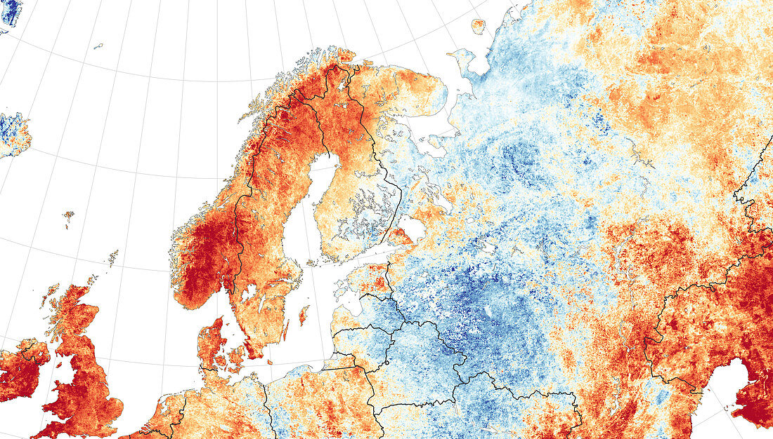
| Scandinavian heat wave, July 2018, satellite image. This image shows land surface temperatures from 1st-15th July 2018, compared to the 2000-2015 average for the same period. Areas that are hotter than normal are red, those that are cooler are blue. These unusually high temperatures, along with a dry spell, lead to the outbreak of more than 40 wildfires in Sweden, the most serious in the country's modern history. Image based on data acquired by the Moderate Resolution Imaging Spectroradiometer (MODIS) on NASA's Terra satellite. | |
| Lizenzart: | Lizenzpflichtig |
| Credit: | Science Photo Library / NASA |
| Bildgröße: | 5540 px × 3155 px |
| Modell-Rechte: | nicht erforderlich |
| Eigentums-Rechte: | nicht erforderlich |
| Restrictions: | - |
Preise für dieses Bild ab 15 €
Universitäten & Organisationen
(Informationsmaterial Digital, Informationsmaterial Print, Lehrmaterial Digital etc.)
ab 15 €
Redaktionell
(Bücher, Bücher: Sach- und Fachliteratur, Digitale Medien (redaktionell) etc.)
ab 30 €
Werbung
(Anzeigen, Aussenwerbung, Digitale Medien, Fernsehwerbung, Karten, Werbemittel, Zeitschriften etc.)
ab 55 €
Handelsprodukte
(bedruckte Textilie, Kalender, Postkarte, Grußkarte, Verpackung etc.)
ab 75 €
Pauschalpreise
Rechtepakete für die unbeschränkte Bildnutzung in Print oder Online
ab 495 €
Keywords
- 2000er Jahre,
- 2018,
- 21. Jahrhundert,
- abnormal,
- Erdbeobachtung,
- Europa,
- europäisch,
- extrem,
- geografisch,
- Geographie,
- heiß,
- Hitze,
- Hitzewelle,
- Juli,
- Klima,
- Klimatologie,
- klimatologisch,
- Meteorologie,
- meteorologisch,
- modis,
- Niemand,
- Norwegen,
- Satellit,
- Schweden,
- Skandinavien,
- Skandinavisch,
- Terra,
- Umwelt,
- Waldbrände,
- Weltall,
- Wetter