Rivers and mountains of the world, 1840s
Bildnummer 12582086
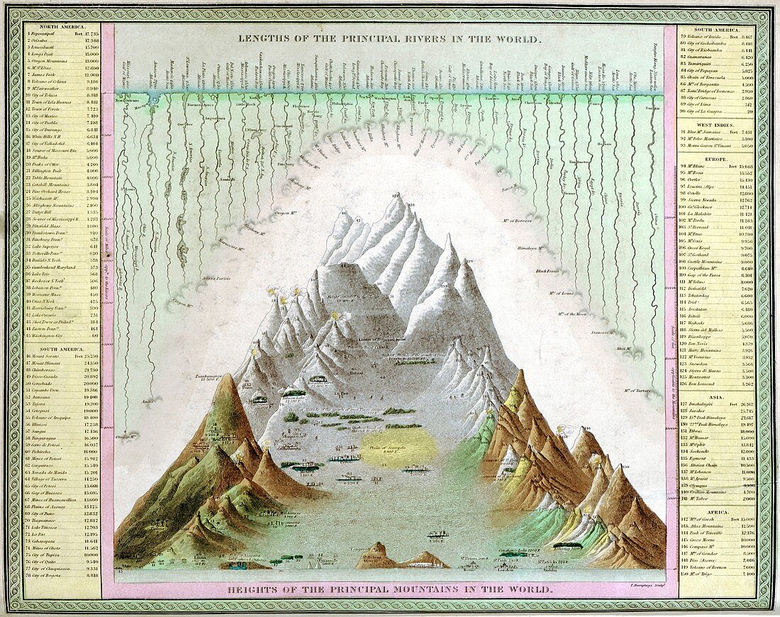
| Rivers and mountains of the world, 1840s. This map is from an atlas published in the USA in 1849 by Samuel Augustus Mitchell (1792-1868). The highest mountain shown is Dwahalagiri (Dhaulagiri) in Nepal, given as 26, 262 feet in elevation (8004 metres), but now known to be 8167 metres. This mountain was presumed to be the world's highest from 1808 until 1847. It wasn't until 1852 that Mount Everest was established as the world's highest mountain. Similarly, the relative lengths of various rivers (especially the Missouri, Amazon, Nile and Yangtze) are inaccurate compared to modern measurements. Various cities and other landmarks are shown at various elevations on the main landscape. | |
| Lizenzart: | Lizenzpflichtig |
| Credit: | Science Photo Library / Library Of Congress, Geography And Map Division |
| Bildgröße: | 4701 px × 3718 px |
| Modell-Rechte: | nicht erforderlich |
| Eigentums-Rechte: | nicht erforderlich |
| Restrictions: | - |
Preise für dieses Bild ab 15 €
Universitäten & Organisationen
(Informationsmaterial Digital, Informationsmaterial Print, Lehrmaterial Digital etc.)
ab 15 €
Redaktionell
(Bücher, Bücher: Sach- und Fachliteratur, Digitale Medien (redaktionell) etc.)
ab 30 €
Werbung
(Anzeigen, Aussenwerbung, Digitale Medien, Fernsehwerbung, Karten, Werbemittel, Zeitschriften etc.)
ab 55 €
Handelsprodukte
(bedruckte Textilie, Kalender, Postkarte, Grußkarte, Verpackung etc.)
ab 75 €
Pauschalpreise
Rechtepakete für die unbeschränkte Bildnutzung in Print oder Online
ab 495 €
Keywords
- 1800er Jahre,
- 19. Jahrhundert,
- Amerikanisch,
- Atlas,
- Berg,
- Berge,
- Blatt,
- Buch,
- Donau,
- Fluss,
- Flüsse,
- geografisch,
- Geographie,
- Geschichte,
- historisch,
- Illustration,
- Karte,
- Kunstwerk,
- Loire,
- Missouri,
- Mount Everest,
- Nepal,
- Niemand,
- Nil,
- Rhone,
- uns,
- Veröffentlichung,
- Welt