Hurricanes Irma and Katia, satellite image
Bildnummer 12395101
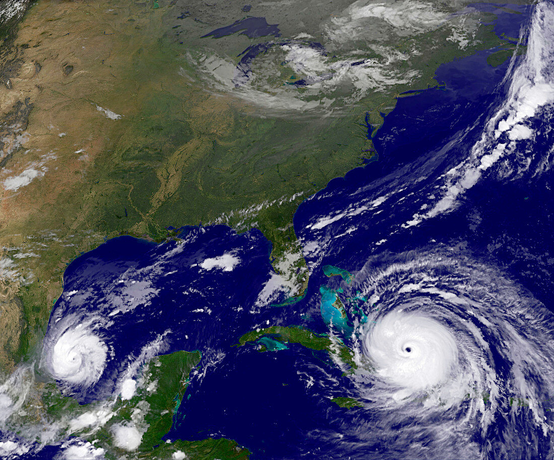
| Satellite image of Hurricane Irma over the Turks and Caicos Islands and Hurricane Katia off the Mexican Gulf coast. Irma made landfall on the Leeward Islands as a category 5 storm with sustained winds of 295 kilometres per hour in the early morning of the 6th September. First hit was Barbuda, where over 90% of buildings were destroyed. Significant damage and loss of life were reported on the other Leeward Islands as Irma continued northwards. Katia became a category 1 hurricane on the afternoon of the 6th and is expected to strengthen as it heads west towards Mexico. Data obtained by the Geostationary Operational Environmental Satellite (GOES) 13 on 8th September 2017. | |
| Lizenzart: | Lizenzpflichtig |
| Credit: | Science Photo Library / NOAA / GOES project / NASA GSFC |
| Bildgröße: | 3900 px × 3236 px |
| Modell-Rechte: | nicht erforderlich |
| Eigentums-Rechte: | nicht erforderlich |
| Restrictions: |
|
Preise für dieses Bild ab 15 €
Universitäten & Organisationen
(Informationsmaterial Digital, Informationsmaterial Print, Lehrmaterial Digital etc.)
ab 15 €
Redaktionell
(Bücher, Bücher: Sach- und Fachliteratur, Digitale Medien (redaktionell) etc.)
ab 30 €
Werbung
(Anzeigen, Aussenwerbung, Digitale Medien, Fernsehwerbung, Karten, Werbemittel, Zeitschriften etc.)
ab 55 €
Handelsprodukte
(bedruckte Textilie, Kalender, Postkarte, Grußkarte, Verpackung etc.)
ab 75 €
Pauschalpreise
Rechtepakete für die unbeschränkte Bildnutzung in Print oder Online
ab 495 €
Keywords
- 2000er Jahre,
- 2017,
- 21. Jahrhundert,
- Atlantischer Ozean,
- Auge,
- Erdbeobachtung,
- Erde,
- Globus,
- Golf von Mexiko,
- Hurrikan,
- Irma,
- Karibik,
- Kategorie 5,
- Klimatologie,
- klimatologisch,
- Kuba,
- Meteorologie,
- meteorologisch,
- Mexiko,
- Naturkatastrophe,
- Niemand,
- Planet,
- Satellit,
- Satellitenbild,
- Sturm,
- tödlich,
- Weltall,
- Wetter