Hurricane Irma rainfall, 3D satellite image
Bildnummer 12394988
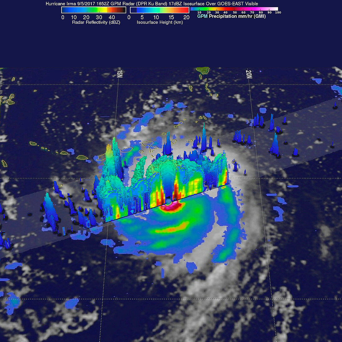
| 3D satellite image showing rainfall and storm height in the eye wall of Hurricane Irma as it approached the Leeward Islands on the 5th September 2017. Storms rotating around the eye were reaching altitudes of more than 12.5 kilometres, while the tallest were to the southwest of Irma's eye, reaching 16.2 kilometres. Irma made landfall on the Leeward Islands as a category 5 storm with sustained winds of 295 kilometres per hour in the early morning of the 6th September. First hit was Barbuda, where over 90% of buildings were destroyed. Significant damage and loss of life were reported on the other Leeward Islands as Irma continued northwards. Data obtained by the Global Precipitation Measurement satellite's Dual-Frequency Precipitation Radar (DPR) instrument. | |
| Lizenzart: | Lizenzpflichtig |
| Credit: | Science Photo Library / JAXA, Hal Pierce / NASA |
| Bildgröße: | 3000 px × 3000 px |
| Modell-Rechte: | nicht erforderlich |
| Eigentums-Rechte: | nicht erforderlich |
| Restrictions: |
|
Preise für dieses Bild ab 15 €
Universitäten & Organisationen
(Informationsmaterial Digital, Informationsmaterial Print, Lehrmaterial Digital etc.)
ab 15 €
Redaktionell
(Bücher, Bücher: Sach- und Fachliteratur, Digitale Medien (redaktionell) etc.)
ab 30 €
Werbung
(Anzeigen, Aussenwerbung, Digitale Medien, Fernsehwerbung, Karten, Werbemittel, Zeitschriften etc.)
ab 55 €
Handelsprodukte
(bedruckte Textilie, Kalender, Postkarte, Grußkarte, Verpackung etc.)
ab 75 €
Pauschalpreise
Rechtepakete für die unbeschränkte Bildnutzung in Print oder Online
ab 495 €
Keywords
- 2000er Jahre,
- 2017,
- 21. Jahrhundert,
- Analyse,
- Atlantischer Ozean,
- Auge,
- Erdbeobachtung,
- globale Niederschlagsmessung,
- GPM,
- Hurrikan,
- Irma,
- Kategorie 5,
- Klimatologie,
- klimatologisch,
- Meteorologie,
- meteorologisch,
- Naturkatastrophe,
- Niemand,
- Regen,
- regnet,
- Satellit,
- Satellitenbild,
- Sturm,
- tödlich,
- Weltall,
- Wetter