Alexandria, 16th century
Bildnummer 12362433
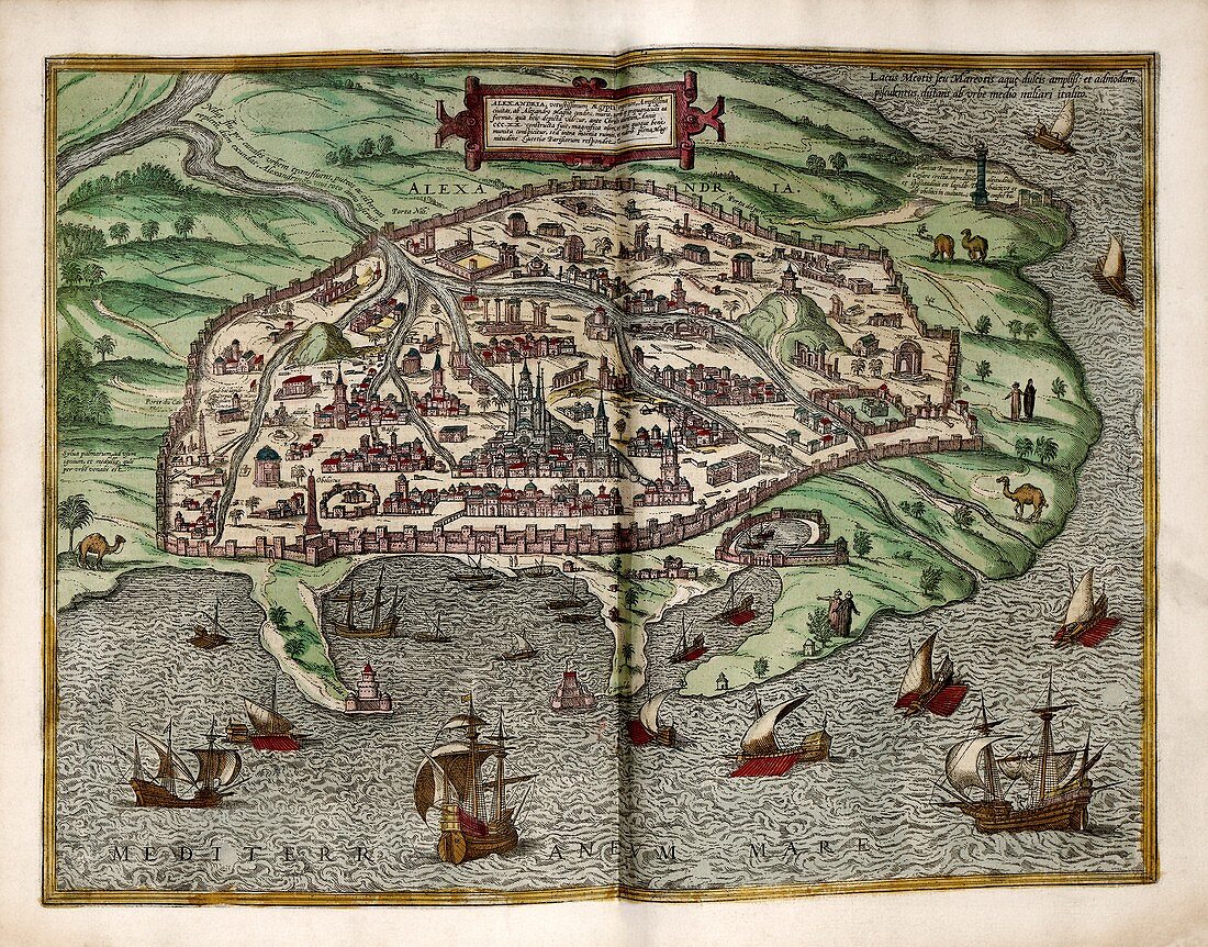
| Alexandria. 16th-century perspective view of the city of Alexandria in Egypt, with a branch of the River Nile and sailing ships at sea and in the harbour. Alexandria, a major port on the Mediterranean Sea, was named for and founded in 331 BC by Alexander the Great. The famed Lighthouse of Alexandria (Pharos) is at lower left. This is a 1612 edition of a map first published in volume 2 (1575) of the city atlas 'Civitates orbis terrarum'. This atlas was edited by Georg Braun (c.1540-1622) and largely engraved by Franz Hogenberg. | |
| Lizenzart: | Lizenzpflichtig |
| Credit: | Science Photo Library / LIBRARY OF CONGRESS, Geography and Map Division |
| Bildgröße: | 5803 px × 4547 px |
| Modell-Rechte: | nicht erforderlich |
| Eigentums-Rechte: | nicht erforderlich |
| Restrictions: | - |
Preise für dieses Bild ab 15 €
Universitäten & Organisationen
(Informationsmaterial Digital, Informationsmaterial Print, Lehrmaterial Digital etc.)
ab 15 €
Redaktionell
(Bücher, Bücher: Sach- und Fachliteratur, Digitale Medien (redaktionell) etc.)
ab 30 €
Werbung
(Anzeigen, Aussenwerbung, Digitale Medien, Fernsehwerbung, Karten, Werbemittel, Zeitschriften etc.)
ab 55 €
Handelsprodukte
(bedruckte Textilie, Kalender, Postkarte, Grußkarte, Verpackung etc.)
ab 75 €
Pauschalpreise
Rechtepakete für die unbeschränkte Bildnutzung in Print oder Online
ab 495 €
Keywords
- 1500er Jahre,
- 16. Jahrhundert,
- 1600er Jahre,
- 17. Jahrhundert,
- Afrika,
- Afrikanisch,
- Ägypten,
- Ägyptisch,
- Alexandria,
- Civitates Orbis Terrarum,
- Deutsche,
- Franz Hogenberg,
- Gebäude,
- geografisch,
- Geographie,
- Georg Braun,
- Geschichte,
- Hafen,
- Häuser,
- historisch,
- Illustration,
- Karte,
- Kartographie,
- Kunstwerk,
- Küste,
- Küsten-,
- Land,
- Latein,
- Maritim,
- Meer,
- Mittelmeer,
- moschee,
- Muslim,
- Niemand,
- Nordafrika,
- Nordafrikanisch,
- perspektivische Ansicht,
- Pharos von Alexandria,
- Reisen,
- Schiffe,
- Segeln,
- Segelschiffe,
- Stadt