Eratosthenes' experiment, illustration
Bildnummer 12361817
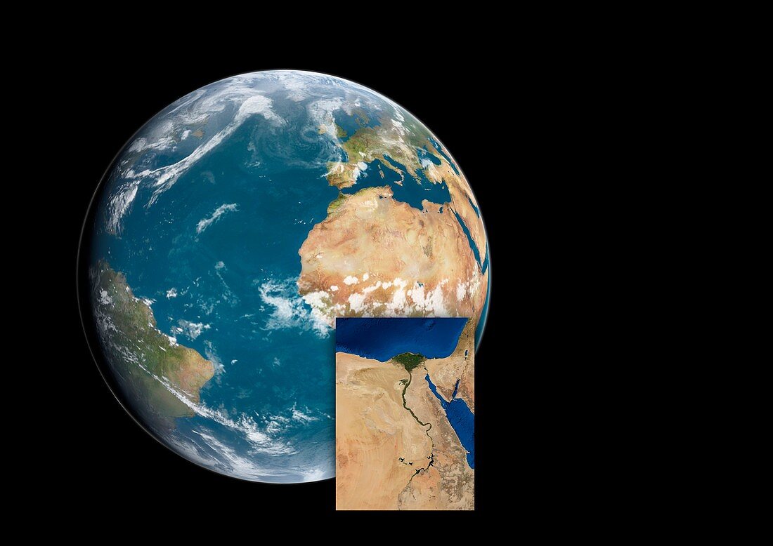
| Eratosthenes' experiment. Illustration using satellite images of an Earth globe with an inset map of Egypt, part of a diagram showing the measurements and calculations made by the 2nd-century-BC Ancient Greek geographer Eratosthenes to determine the circumference of the Earth. In Egypt, Alexandria is due north of Syene (modern-day Aswan). It was here that Eratosthenes measured the angle of elevation of the Sun from the zenith on the summer solstice, when the Sun was directly overhead in Syene. The circumference of the Earth is the Syene-Alexandria distance, multiplied by 360 degrees and divided by the measured angle of solar elevation. His result (39, 690 kilometres) was close to the modern value of 40, 075 kilometres. Labelled version available. | |
| Lizenzart: | Lizenzpflichtig |
| Credit: | Science Photo Library / JOSE ANTONIO PENAS |
| Bildgröße: | 5696 px × 4028 px |
| Modell-Rechte: | nicht erforderlich |
| Eigentums-Rechte: | nicht erforderlich |
| Restrictions: | - |
Preise für dieses Bild ab 15 €
Universitäten & Organisationen
(Informationsmaterial Digital, Informationsmaterial Print, Lehrmaterial Digital etc.)
ab 15 €
Redaktionell
(Bücher, Bücher: Sach- und Fachliteratur, Digitale Medien (redaktionell) etc.)
ab 30 €
Werbung
(Anzeigen, Aussenwerbung, Digitale Medien, Fernsehwerbung, Karten, Werbemittel, Zeitschriften etc.)
ab 55 €
Handelsprodukte
(bedruckte Textilie, Kalender, Postkarte, Grußkarte, Verpackung etc.)
ab 75 €
Pauschalpreise
Rechtepakete für die unbeschränkte Bildnutzung in Print oder Online
ab 495 €
Keywords
- Afrika,
- Afrikanisch,
- Ägypten,
- Ägyptisch,
- Alexandria,
- Altgriechisch,
- Antike,
- antikes Griechenland,
- Assuan,
- ausgeschnitten,
- Ausschnitte,
- Diagramm,
- Erde,
- Experiment,
- geografisch,
- Geographie,
- Geometrie,
- geometrisch,
- Geschichte,
- historisch,
- Illustration,
- klassisch,
- Kunstwerk,
- Mathematik,
- mathematisch,
- Messung,
- Mittelmeer,
- Niemand,
- Planet,
- Satellit,
- Satellitenbild,
- schwarzer Hintergrund,
- Sonnenlicht,
- Weltall,
- Winkel