USA and city lights, GLOBE map
Bildnummer 12361546
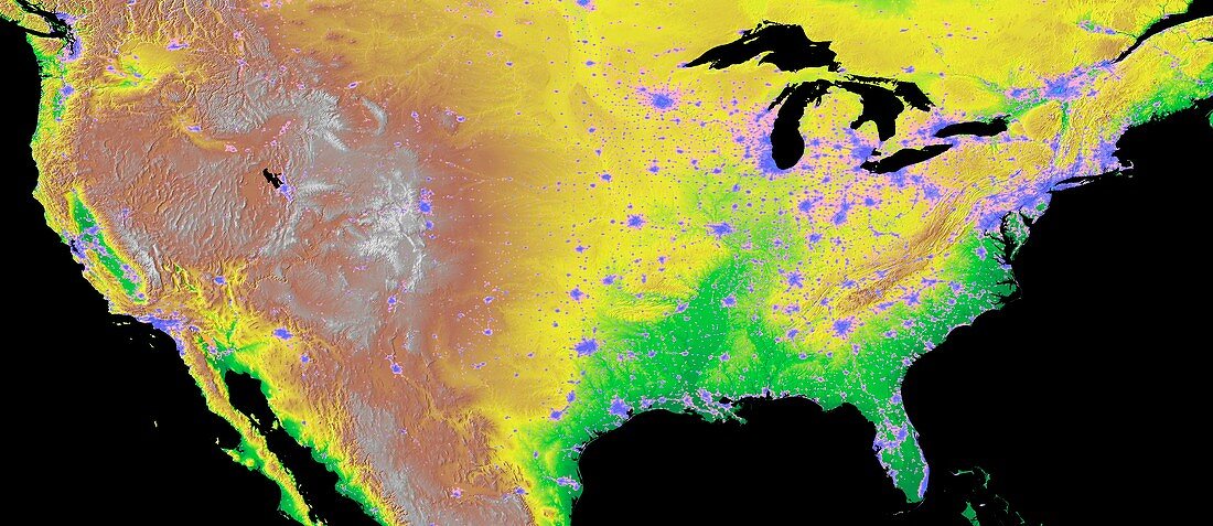
| USA and city lights, GLOBE map. Topographic map of the contiguous United States of America (USA), combining GLOBE elevations with city lights data. Colours on land indicate elevation above sea level. The colour-coding (low to high) ranges from green to yellow to red to white, with relief also shown. GLOBE (Global Land One-kilometer Base Elevation) is a global digital elevation model (DEM), produced by the National Geophysical Data Center (NGDC) of the National Oceanic and Atmospheric Administration (NOAA). It incorporates data from a range of different sources. Since 2015, GLOBE data has been collated and published by NOAA's National Centers for Environmental Information (NCEI). The city lights data (purple-grey) is from satellites operated under the Defense Meteorological Satellite Program (DMSP). | |
| Lizenzart: | Lizenzpflichtig |
| Credit: | Science Photo Library / NOAA |
| Bildgröße: | 8073 px × 3498 px |
| Modell-Rechte: | nicht erforderlich |
| Eigentums-Rechte: | nicht erforderlich |
| Restrictions: |
|
Preise für dieses Bild ab 15 €
Universitäten & Organisationen
(Informationsmaterial Digital, Informationsmaterial Print, Lehrmaterial Digital etc.)
ab 15 €
Redaktionell
(Bücher, Bücher: Sach- und Fachliteratur, Digitale Medien (redaktionell) etc.)
ab 30 €
Werbung
(Anzeigen, Aussenwerbung, Digitale Medien, Fernsehwerbung, Karten, Werbemittel, Zeitschriften etc.)
ab 55 €
Handelsprodukte
(bedruckte Textilie, Kalender, Postkarte, Grußkarte, Verpackung etc.)
ab 75 €
Pauschalpreise
Rechtepakete für die unbeschränkte Bildnutzung in Print oder Online
ab 495 €