Pine Island Glacier ice flow, satellite radar image
Bildnummer 12257801
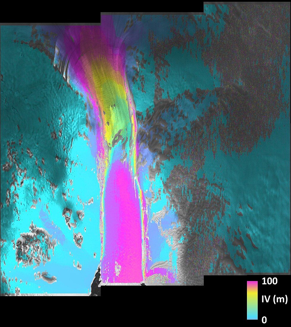
| Pine Island Glacier ice flow. Satellite radar image of ice flow on Pine Island Glacier in West Antarctica, as surveyed by the Sentinel-1A satellite in March 2015. The image combines two scans, showing that parts of the Pine Island Glacier flowed about 100 metres (pink area) between 3 and 15 March 2015. Light blue represents stable ice on either side of the ice stream. Pine Island is the largest glacier in the West Antarctic Ice Sheet and one of the fastest ice streams on the continent, moving at an average speed of over 4 kilometres per year. The Sentinel-1 satellite program is an important tool for monitoring polar regions and the effects that climate change has on ice. | |
| Lizenzart: | Lizenzpflichtig |
| Credit: | Science Photo Library / University of Leeds, Centre for Polar Observation and Modelling (CPOM) / A. Hogg / ESA / Copernicus data (2015) |
| Bildgröße: | 1620 px × 1823 px |
| Modell-Rechte: | nicht erforderlich |
| Eigentums-Rechte: | nicht erforderlich |
| Restrictions: |
|
Preise für dieses Bild ab 15 €
Universitäten & Organisationen
(Informationsmaterial Digital, Informationsmaterial Print, Lehrmaterial Digital etc.)
ab 15 €
Redaktionell
(Bücher, Bücher: Sach- und Fachliteratur, Digitale Medien (redaktionell) etc.)
ab 30 €
Werbung
(Anzeigen, Aussenwerbung, Digitale Medien, Fernsehwerbung, Karten, Werbemittel, Zeitschriften etc.)
ab 55 €
Handelsprodukte
(bedruckte Textilie, Kalender, Postkarte, Grußkarte, Verpackung etc.)
ab 75 €
Pauschalpreise
Rechtepakete für die unbeschränkte Bildnutzung in Print oder Online
ab 495 €