North America portolan chart,1540s
Bildnummer 12098980
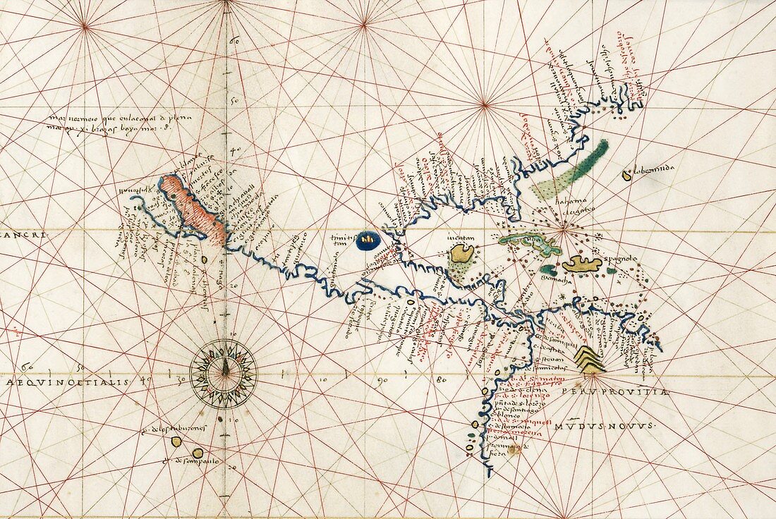
| North America portolan chart. 16th-century portolan atlas chart showing North America in around 1544. The Gulf of California (centre left),discovered by Ulloa in 1539,is shown with its reddish tint. California is shown as a peninsula,not an island. At centre right,the Yucatan peninsula is shown as an island. Mexico City (in its lake) is at centre),and Peru's mountains are at lower right. The green area at upper right is thought to be an early indication of the Gulf Stream. The portolan rhumb lines and naming of rivers and ports along the coastlines aid navigation. This map was produced by Italian cartographer Battista Agnese (c.1500-1564) | |
| Lizenzart: | Lizenzpflichtig |
| Credit: | Science Photo Library / LIBRARY OF CONGRESS, Geography and Map Division |
| Bildgröße: | 3973 px × 2657 px |
| Modell-Rechte: | nicht erforderlich |
| Eigentums-Rechte: | nicht erforderlich |
| Restrictions: | - |
Preise für dieses Bild ab 15 €
Universitäten & Organisationen
(Informationsmaterial Digital, Informationsmaterial Print, Lehrmaterial Digital etc.)
ab 15 €
Redaktionell
(Bücher, Bücher: Sach- und Fachliteratur, Digitale Medien (redaktionell) etc.)
ab 30 €
Werbung
(Anzeigen, Aussenwerbung, Digitale Medien, Fernsehwerbung, Karten, Werbemittel, Zeitschriften etc.)
ab 55 €
Handelsprodukte
(bedruckte Textilie, Kalender, Postkarte, Grußkarte, Verpackung etc.)
ab 75 €
Pauschalpreise
Rechtepakete für die unbeschränkte Bildnutzung in Print oder Online
ab 495 €
Keywords
- 1500er Jahre,
- 16. Jahrhundert,
- Atlantisch,
- Atlas,
- Bahamas,
- Blatt,
- Buch,
- Diagramm,
- geografisch,
- Geographie,
- Geschichte,
- Golf von Kalifornien,
- historisch,
- Illustration,
- Kalifornien,
- Karibik,
- Karte,
- Kartographie,
- Kontinent,
- Kuba,
- Kunstwerk,
- Küsten,
- Küsten-,
- Küstenlinie,
- Land,
- Meer,
- Mexiko,
- Niemand,
- Nordamerika,
- nordamerikanisch,
- Ozean,
- Pazifik,
- Peru,
- See,
- Tenochtitlan,
- Veröffentlichung