Map of New York Bay,1670
Bildnummer 11946505
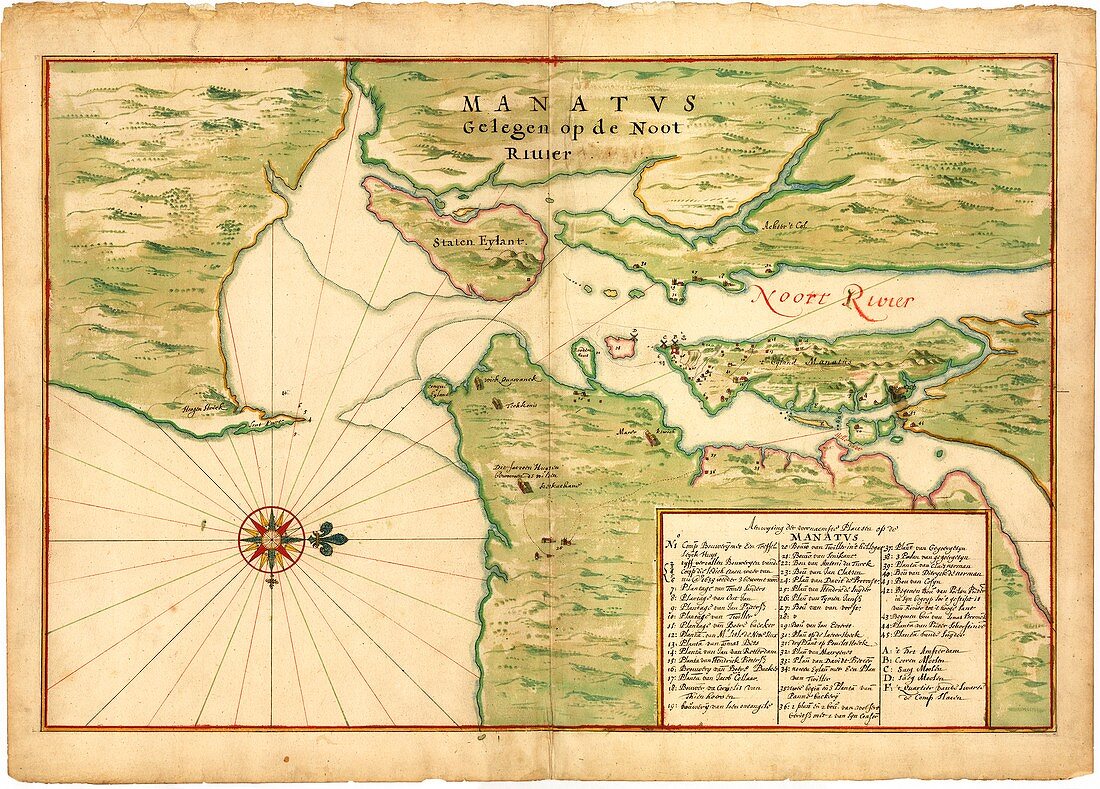
| Map of New York Bay. 17th-century map of New York Bay (north towards right),produced in 1670 by Dutch cartographer Johannes Vingboons (c.1616-1670). The first European settlers here were Dutch,part of New Netherland. They established New Amsterdam (later New York City) on Manhattan Island (centre right). At lower right is an index of buildings with the names of the householders. Dutch windmills are shown,as well as the long-houses of indigenous peoples. Staten Island is at upper centre,with the Hudson River and East River at right. Long Island is at lower right. Part of New Jersey is at upper left,with mainland New York at upper right | |
| Lizenzart: | Lizenzpflichtig |
| Credit: | Science Photo Library / LIBRARY OF CONGRESS, Geography and Map Division |
| Bildgröße: | 5442 px × 3904 px |
| Modell-Rechte: | nicht erforderlich |
| Eigentums-Rechte: | nicht erforderlich |
| Restrictions: | - |
Preise für dieses Bild ab 15 €
Universitäten & Organisationen
(Informationsmaterial Digital, Informationsmaterial Print, Lehrmaterial Digital etc.)
ab 15 €
Redaktionell
(Bücher, Bücher: Sach- und Fachliteratur, Digitale Medien (redaktionell) etc.)
ab 30 €
Werbung
(Anzeigen, Aussenwerbung, Digitale Medien, Fernsehwerbung, Karten, Werbemittel, Zeitschriften etc.)
ab 55 €
Handelsprodukte
(bedruckte Textilie, Kalender, Postkarte, Grußkarte, Verpackung etc.)
ab 75 €
Pauschalpreise
Rechtepakete für die unbeschränkte Bildnutzung in Print oder Online
ab 495 €
Keywords
- 1600er Jahre,
- 17. Jahrhundert,
- Amerikanisch,
- Atlantisch,
- Bucht,
- East River,
- geografisch,
- Geographie,
- Geschichte,
- historisch,
- Illustration,
- Karte,
- Kartographie,
- Kunstwerk,
- Küste,
- Küsten,
- Küsten-,
- Küstenlinie,
- Long Island,
- Namen,
- New Holland,
- New Jersey,
- New York City,
- Niederländisch,
- Niemand,
- Nordamerika,
- nordamerikanisch,
- Staten Island,
- USA,
- Vereinigte Staaten,
- Windmühlen