Mars topographical map,satellite image
Bildnummer 11882465
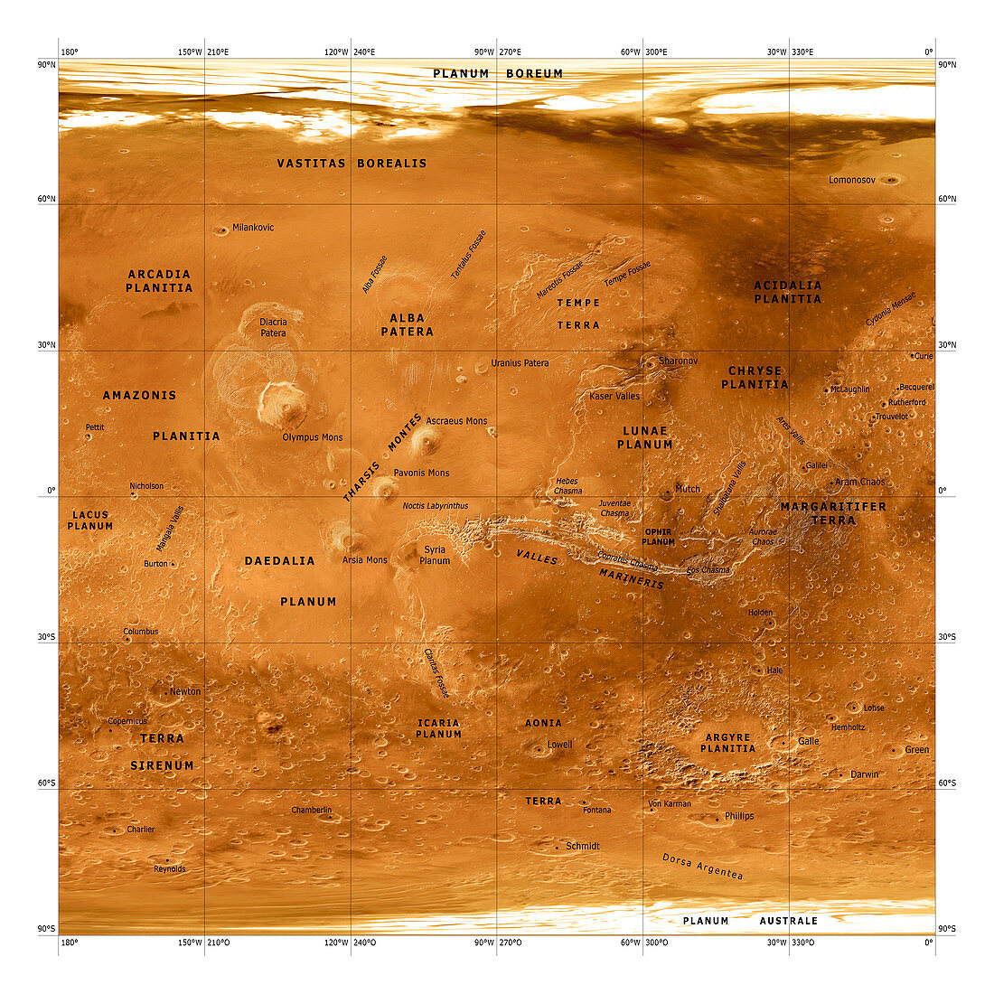
| Mars topographical map. Three-dimensional composite satellite image of the surface of Mars. Topographical features are labelled in black. North is at top. Features visible include the Chryse Planitia (centre right),a plain with a diameter of around 840 kilometres,and Olympus Mons (centre left),the tallest known volcano and mountain in our solar system. The map was created using data from the Mars Global Surveyor spacecraft's Mars Orbiter Laser Altimeter | |
| Lizenzart: | Lizenzpflichtig |
| Credit: | Science Photo Library / Van Ravenswaay, Detlev |
| Bildgröße: | 4016 px × 4016 px |
| Modell-Rechte: | nicht erforderlich |
| Eigentums-Rechte: | nicht erforderlich |
| Restrictions: | - |
Preise für dieses Bild ab 15 €
Universitäten & Organisationen
(Informationsmaterial Digital, Informationsmaterial Print, Lehrmaterial Digital etc.)
ab 15 €
Redaktionell
(Bücher, Bücher: Sach- und Fachliteratur, Digitale Medien (redaktionell) etc.)
ab 30 €
Werbung
(Anzeigen, Aussenwerbung, Digitale Medien, Fernsehwerbung, Karten, Werbemittel, Zeitschriften etc.)
ab 55 €
Handelsprodukte
(bedruckte Textilie, Kalender, Postkarte, Grußkarte, Verpackung etc.)
ab 75 €
Pauschalpreise
Rechtepakete für die unbeschränkte Bildnutzung in Print oder Online
ab 495 €
Keywords
- 3 dimensional,
- 3-d,
- 3-dimensional,
- 3D,
- abgebildet,
- Astronomie,
- astronomisch,
- Astrophysik,
- astrophysikalisch,
- beschriftet,
- Braun,
- Dreidimensional,
- einfach,
- Karte,
- Krater,
- Mars,
- Mars Global Surveyor,
- MGS,
- Mola,
- Oberfläche,
- Olympus Mons,
- Planet,
- planetarisch,
- Planetenwissenschaft,
- Raum,
- Raumschiff,
- Region,
- Satellitenbild,
- Sonnensystem,
- topografisch,
- Topographie,
- topographisch,
- vom Mars,
- Vulkan,
- Vulkane,
- Weltall,
- Zusammengesetzt