Martian topography
Bildnummer 11882270
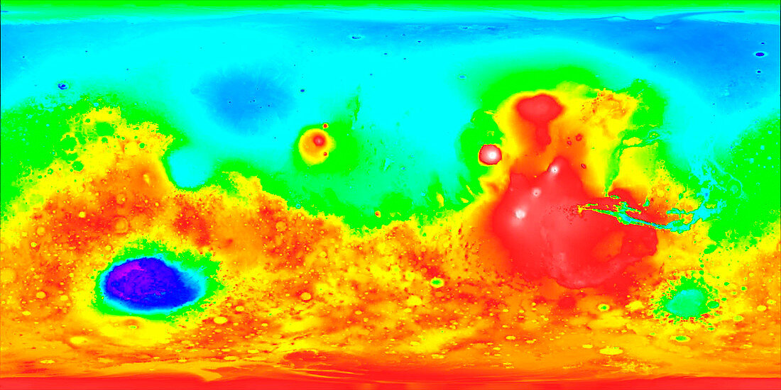
| Martian topography. Three-dimensional map of the topography of Mars. Elevation is colour-coded,from white (highest) through red,yellow,green and blue to purple (lowest). The Hellas Planitia impact basin is at lower left (purple). Three volcanoes (white) are seen in a line on the Tharsis Ridge (red) at centre right. From bottom left to top right,these are Arsia Mons,Pavonis Mons and Ascraeus Mons. To their left is Olympus Mons (white),the largest volcano in the solar system. Data collected by the Mars Orbiter Laser Altimeter (MOLA) on the Mars Global Surveyor spacecraft. 27 million height measurements were made by timing laser pulses sent to Mars' surface | |
| Lizenzart: | Lizenzpflichtig |
| Credit: | Science Photo Library / NASA |
| Bildgröße: | 2432 px × 1216 px |
| Modell-Rechte: | nicht erforderlich |
| Eigentums-Rechte: | nicht erforderlich |
| Restrictions: | - |
Preise für dieses Bild ab 15 €
Universitäten & Organisationen
(Informationsmaterial Digital, Informationsmaterial Print, Lehrmaterial Digital etc.)
ab 15 €
Redaktionell
(Bücher, Bücher: Sach- und Fachliteratur, Digitale Medien (redaktionell) etc.)
ab 30 €
Werbung
(Anzeigen, Aussenwerbung, Digitale Medien, Fernsehwerbung, Karten, Werbemittel, Zeitschriften etc.)
ab 55 €
Handelsprodukte
(bedruckte Textilie, Kalender, Postkarte, Grußkarte, Verpackung etc.)
ab 75 €
Pauschalpreise
Rechtepakete für die unbeschränkte Bildnutzung in Print oder Online
ab 495 €