Bhuj,radar image
Bildnummer 11748773
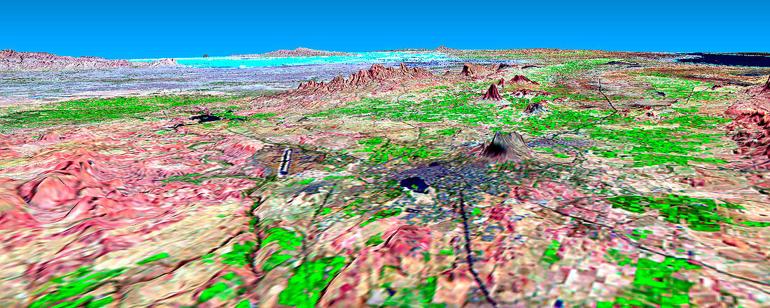
| Bhuj city. Coloured three-dimensional computer map of the city of Bhuj (centre right),in Kachchh,India. The land topography was mapped by the Shuttle Radar Topography Mission (SRTM) on the Space Shuttle Endeavour,using reflected radar pulses. Colours are from a Landsat 7 image. Roads (black) and the airport (black/white strip,centre left) are seen. Nearby hills (red) rise to 500 metres. The Gulf of Kachchh (dark blue,top right) and low-lying salt flats (light blue,upper left) are also seen. This region was devastated by an earthquake in January 2001. SRTM is run by NASA,the USA's National Imagery and Mapping Agency (NIMA),and the German and Italian space agencies | |
| Lizenzart: | Lizenzpflichtig |
| Credit: | Science Photo Library / NASA |
| Bildgröße: | 1566 px × 626 px |
| Modell-Rechte: | nicht erforderlich |
| Eigentums-Rechte: | nicht erforderlich |
| Restrictions: | - |
Preise für dieses Bild ab 15 €
Universitäten & Organisationen
(Informationsmaterial Digital, Informationsmaterial Print, Lehrmaterial Digital etc.)
ab 15 €
Redaktionell
(Bücher, Bücher: Sach- und Fachliteratur, Digitale Medien (redaktionell) etc.)
ab 30 €
Werbung
(Anzeigen, Aussenwerbung, Digitale Medien, Fernsehwerbung, Karten, Werbemittel, Zeitschriften etc.)
ab 55 €
Handelsprodukte
(bedruckte Textilie, Kalender, Postkarte, Grußkarte, Verpackung etc.)
ab 75 €
Pauschalpreise
Rechtepakete für die unbeschränkte Bildnutzung in Print oder Online
ab 495 €
Keywords
- 3-d,
- abgebildet,
- Amerikanisch,
- Deutsche,
- Dorf,
- Dreidimensional,
- Ebene,
- Erdbeben,
- farbig,
- Flughafen,
- geografisch,
- Geographie,
- Geologie,
- geologisch,
- Indien,
- Indisch,
- Italienisch,
- Karte,
- Karten,
- Land,
- Landsat 7,
- Meer,
- Mission,
- NASA,
- Oberfläche,
- Ozean,
- Salz,
- Satellit,
- SRTM,
- Stadt,
- Städte,
- städtisch,
- Straße,
- Terrain,
- topografisch,
- uns,
- Urbanisierung,
- Vegetation,
- Wasser,
- Weltall