Mount Baldy,radar image
Bildnummer 11744666
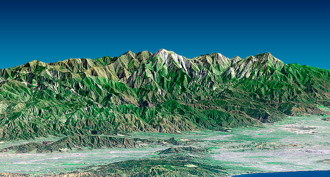
| Mount Baldy. Coloured three-dimensional computer map of Mount Baldy (white peak,upper centre) and the San Gabriel mountains,California,USA. The land topography was mapped by the Shuttle Radar Topography Mission (SRTM) on the Space Shuttle Endeavour,using reflected radar pulses. Colours are from the Landsat 7 satellite. Mount Baldy is 3068 metres tall. Santa Monica (grey,bottom right) lies near the Pacific Ocean (blue) and the Santa Monica mountains (green,bottom centre). Los Angeles (grey,lower right) is close to the San Gabriel range. SRTM is run by NASA,the USA's National Imagery and Mapping Agency (NIMA),and the German and Italian space agencies | |
| Lizenzart: | Lizenzpflichtig |
| Credit: | Science Photo Library / NASA |
| Bildgröße: | 1725 px × 928 px |
| Modell-Rechte: | nicht erforderlich |
| Eigentums-Rechte: | nicht erforderlich |
| Restrictions: | - |
Preise für dieses Bild ab 15 €
Universitäten & Organisationen
(Informationsmaterial Digital, Informationsmaterial Print, Lehrmaterial Digital etc.)
ab 15 €
Redaktionell
(Bücher, Bücher: Sach- und Fachliteratur, Digitale Medien (redaktionell) etc.)
ab 30 €
Werbung
(Anzeigen, Aussenwerbung, Digitale Medien, Fernsehwerbung, Karten, Werbemittel, Zeitschriften etc.)
ab 55 €
Handelsprodukte
(bedruckte Textilie, Kalender, Postkarte, Grußkarte, Verpackung etc.)
ab 75 €
Pauschalpreise
Rechtepakete für die unbeschränkte Bildnutzung in Print oder Online
ab 495 €
Keywords
- 3-d,
- abgebildet,
- Amerika,
- Amerikanisch,
- Berg,
- Berge,
- Deutsche,
- Dreidimensional,
- farbig,
- geografisch,
- Geographie,
- Geologie,
- geologisch,
- Gipfel,
- Italienisch,
- Kalifornien,
- Kalifornisch,
- Karte,
- Karten,
- Land,
- Meer,
- Mission,
- Monica,
- NASA,
- Oberfläche,
- Ozean,
- Pazifik,
- Reichweite,
- Santa,
- SRTM,
- Terrain,
- topografisch,
- uns,
- Vereinigte Staaten,
- vulkanisch,
- Wasser,
- Weltall