Mount Shasta,radar image
Bildnummer 11740678
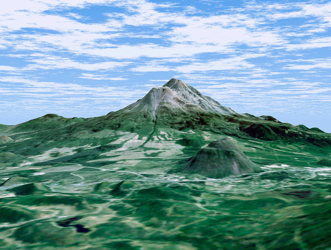
| Mount Shasta. Coloured three-dimensional computer map of Mount Shasta volcano (grey peak,upper centre) in California,USA. The image was produced by the Shuttle Radar Topography Mission (SRTM) on the Space Shuttle Endeavour,which uses reflected radar pulses to map the topography of the land below. The colours were produced by the Landsat 5 satellite. At around 4300 metres,Mount Shasta is California's tallest volcano. Also seen are the volcanoes Shastina (lower peak at centre left) and Black Butte (darker,lower right). SRTM is run by NASA,the USA's National Imagery and Mapping Agency (NIMA),and the German and Italian space agencies | |
| Lizenzart: | Lizenzpflichtig |
| Credit: | Science Photo Library / NASA |
| Bildgröße: | 1152 px × 870 px |
| Modell-Rechte: | nicht erforderlich |
| Eigentums-Rechte: | nicht erforderlich |
| Restrictions: | - |
Preise für dieses Bild ab 15 €
Universitäten & Organisationen
(Informationsmaterial Digital, Informationsmaterial Print, Lehrmaterial Digital etc.)
ab 15 €
Redaktionell
(Bücher, Bücher: Sach- und Fachliteratur, Digitale Medien (redaktionell) etc.)
ab 30 €
Werbung
(Anzeigen, Aussenwerbung, Digitale Medien, Fernsehwerbung, Karten, Werbemittel, Zeitschriften etc.)
ab 55 €
Handelsprodukte
(bedruckte Textilie, Kalender, Postkarte, Grußkarte, Verpackung etc.)
ab 75 €
Pauschalpreise
Rechtepakete für die unbeschränkte Bildnutzung in Print oder Online
ab 495 €
Keywords
- 3-d,
- abgebildet,
- Amerika,
- Amerikanisch,
- Berg,
- Berge,
- Deutsche,
- Dreidimensional,
- farbig,
- geografisch,
- Geographie,
- Geologie,
- geologisch,
- Gipfel,
- Italienisch,
- Kalifornien,
- Kalifornisch,
- Karte,
- Karten,
- Land,
- Mission,
- Mount Shasta,
- NASA,
- Oberfläche,
- SRTM,
- Terrain,
- topografisch,
- uns,
- Vereinigte Staaten,
- Vulkan,
- Vulkane,
- vulkanisch,
- Weltall