Sri Lankan coastline,during 2004 tsunami
Bildnummer 11739831
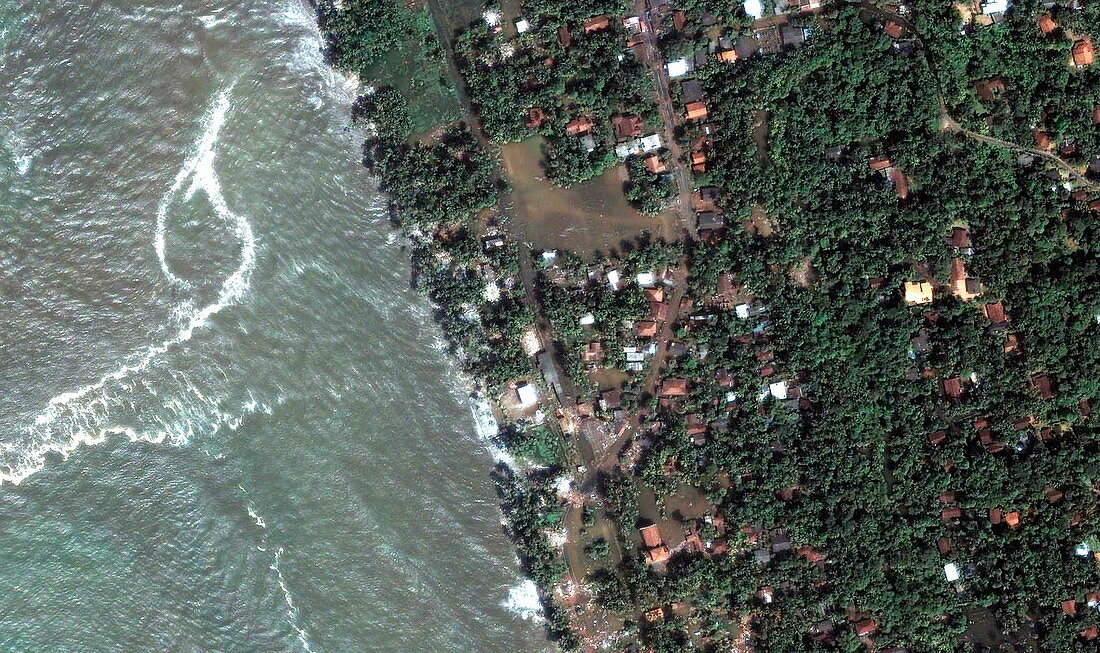
| During tsunami. Image 2 of 4. Satellite image of the Sri Lankan resort area of Kalutara,during the tsunami flooding of 26 December 2004. The beach is submerged and high water is seen around buildings and trees. The floodwaters reached inland off to the right for at least one kilometre. The flooding was caused by a massive underwater earthquake,around 2000 kilometres to the east near Indonesia,that created huge waves,or tsunamis,that spread across the Indian Ocean,killing over 150,000. The full death toll may never be known. Quickbird satellite image. For this coastline before and during the tsunami,see images E275/042-045 | |
| Lizenzart: | Lizenzpflichtig |
| Credit: | Science Photo Library / Digital Globe, Eurimage |
| Bildgröße: | 3253 px × 1931 px |
| Modell-Rechte: | nicht erforderlich |
| Eigentums-Rechte: | nicht erforderlich |
| Restrictions: |
|
Preise für dieses Bild ab 15 €
Universitäten & Organisationen
(Informationsmaterial Digital, Informationsmaterial Print, Lehrmaterial Digital etc.)
ab 15 €
Redaktionell
(Bücher, Bücher: Sach- und Fachliteratur, Digitale Medien (redaktionell) etc.)
ab 30 €
Werbung
(Anzeigen, Aussenwerbung, Digitale Medien, Fernsehwerbung, Karten, Werbemittel, Zeitschriften etc.)
ab 55 €
Handelsprodukte
(bedruckte Textilie, Kalender, Postkarte, Grußkarte, Verpackung etc.)
ab 75 €
Pauschalpreise
Rechtepakete für die unbeschränkte Bildnutzung in Print oder Online
ab 495 €
Keywords
- Asiatisch,
- Asien,
- Baum,
- Bäume,
- bewaldet,
- Dezember,
- Dorf,
- Dörfer,
- Eingehend,
- Erdbeben,
- Erdbeobachtung,
- Flut,
- Flutwelle,
- Gebäude,
- Gipfel,
- Haus,
- Häuser,
- Hotel,
- Indischer Ozean,
- Kalatura,
- Katastrophe,
- Küste,
- Küsten-,
- Küstenlinie,
- ländlich,
- Landschaft,
- natürlich,
- Reihenfolge,
- Resort,
- Satellit,
- Satellitenbild,
- Schaden,
- Schwall,
- seismische Aktivität,
- Seismologie,
- Sri Lanka,
- Strand,
- Strände,
- Straße,
- Tod,
- Tourismus,
- Tourist,
- Touristen,
- Tsunami,
- Überschwemmung,
- Ufer,
- Während,
- Wald,
- Weltall,
- Zerstörung