Hurricane Gustav,31st August 2008
Bildnummer 11738103
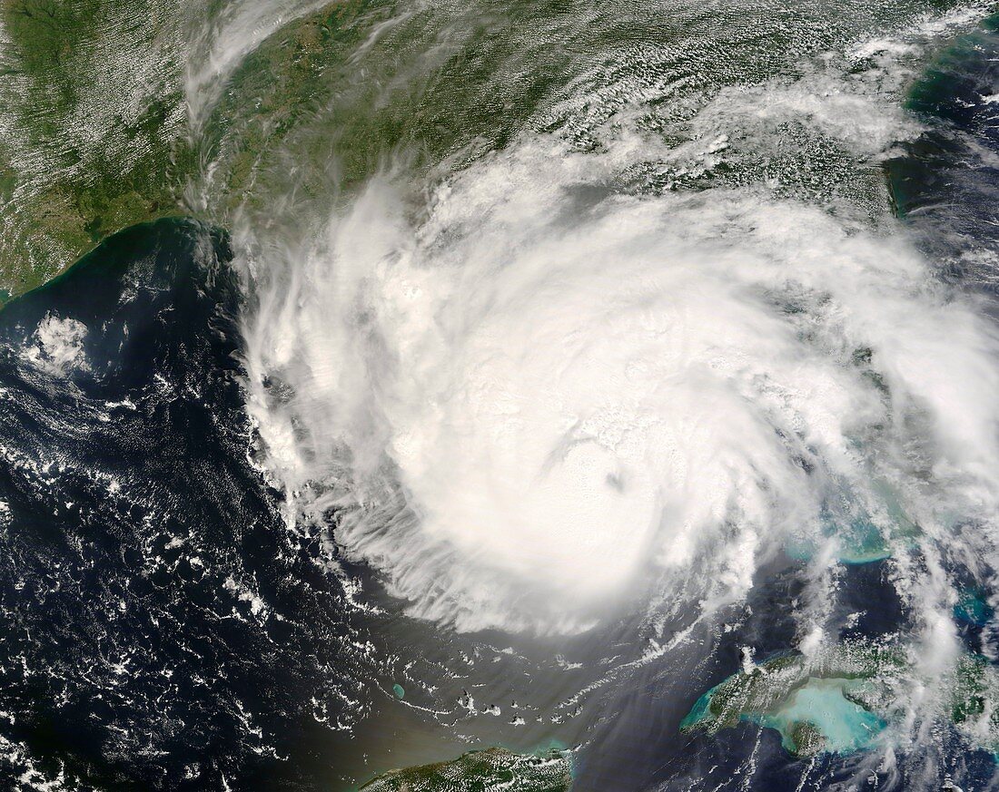
| Hurricane Gustav,satellite image. North is at top. Image obtained on 31st August 2008 at 16:45 UTC,showing Gustav moving east to west towards Louisiana,USA. The land at right of the hurricane's eye is the Florida Peninsula. Gustav was a category 4 hurricane with wind speeds of 240 kilometres per hour (km/h) but on 31st August it dropped to a category 3 level with wind speeds of 185km/h. On 1st September at 14:30 UTC (09:30 local time),the eye of Gustav made landfall on the Louisiana coast as a category 2 hurricane (175km/h). As of 1st September,97 deaths have been attributed to Gustav in the USA and Caribbean. Image from the MODIS instrument on NASA's Terra satellite | |
| Lizenzart: | Lizenzpflichtig |
| Credit: | Science Photo Library / NASA |
| Bildgröße: | 4700 px × 3732 px |
| Modell-Rechte: | nicht erforderlich |
| Eigentums-Rechte: | nicht erforderlich |
| Restrictions: | - |
Preise für dieses Bild ab 15 €
Universitäten & Organisationen
(Informationsmaterial Digital, Informationsmaterial Print, Lehrmaterial Digital etc.)
ab 15 €
Redaktionell
(Bücher, Bücher: Sach- und Fachliteratur, Digitale Medien (redaktionell) etc.)
ab 30 €
Werbung
(Anzeigen, Aussenwerbung, Digitale Medien, Fernsehwerbung, Karten, Werbemittel, Zeitschriften etc.)
ab 55 €
Handelsprodukte
(bedruckte Textilie, Kalender, Postkarte, Grußkarte, Verpackung etc.)
ab 75 €
Pauschalpreise
Rechtepakete für die unbeschränkte Bildnutzung in Print oder Online
ab 495 €
Keywords
- 21. Jahrhundert,
- Amerikanisch,
- Auge,
- August,
- Erdbeobachtung,
- extrem,
- gefährlich,
- Golf von Mexiko,
- Hurrikan,
- Hurrikan Gustav,
- Kategorie 3,
- Klima,
- kraftvoll,
- Kuba,
- Küste,
- Küsten-,
- Landung,
- Louisiana,
- mächtig,
- Meer,
- Meteorologie,
- meteorologisch,
- modis,
- NASA,
- Naturkatastrophe,
- Nordamerika,
- nordamerikanisch,
- Ozean,
- rotierend,
- Satellit,
- Satellitenbild,
- Spektroradiometer,
- Terra,
- Tropisch,
- uns,
- USA,
- Vereinigte Staaten,
- Weltall,
- Wetter,
- Wolke,
- Wolken