East coast of USA
Bildnummer 11735817
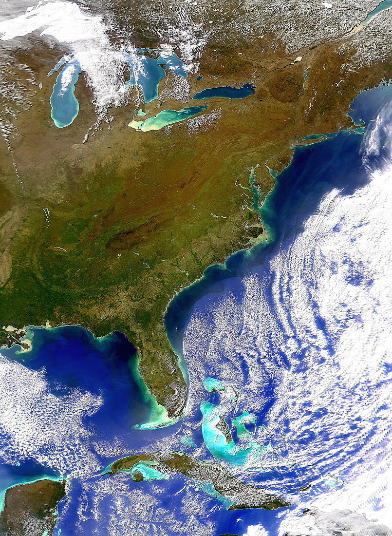
| East coast of the USA. Satellite image of the east coast of the USA. North is at top. Land is brown,water is blue/green and clouds and snow and ice are white. The Atlantic seaboard of the USA runs from Maine (upper right) down to Florida (peninsula,lower left). To the left of Florida is the Gulf of Mexico,with part of Mexico and Belize seen at bottom left. Cuba is at lower centre,with other Caribbean islands at lower right. The Great Lakes (upper left),on the US- Canadian border,are the largest expanse of fresh water in the world | |
| Lizenzart: | Lizenzpflichtig |
| Credit: | Science Photo Library / Digital Globe |
| Bildgröße: | 2261 px × 3088 px |
| Modell-Rechte: | nicht erforderlich |
| Eigentums-Rechte: | nicht erforderlich |
| Restrictions: | - |
Preise für dieses Bild ab 15 €
Universitäten & Organisationen
(Informationsmaterial Digital, Informationsmaterial Print, Lehrmaterial Digital etc.)
ab 15 €
Redaktionell
(Bücher, Bücher: Sach- und Fachliteratur, Digitale Medien (redaktionell) etc.)
ab 30 €
Werbung
(Anzeigen, Aussenwerbung, Digitale Medien, Fernsehwerbung, Karten, Werbemittel, Zeitschriften etc.)
ab 55 €
Handelsprodukte
(bedruckte Textilie, Kalender, Postkarte, Grußkarte, Verpackung etc.)
ab 75 €
Pauschalpreise
Rechtepakete für die unbeschränkte Bildnutzung in Print oder Online
ab 495 €
Keywords
- Amerika,
- Amerikanisch,
- Atlantisch,
- Bild,
- Bilder,
- Bilderwelt,
- Erdkunde,
- Florida,
- Foto,
- Fotos,
- Golf von Mexiko,
- Große Seen,
- Insel,
- Inseln,
- Karibik,
- Kuba,
- Küste,
- Küsten-,
- Land,
- Meer,
- Norden,
- Osten,
- Ozean,
- Satellitenbild,
- See,
- uns,
- USA,
- Vereinigte Staaten,
- Wasser,
- Weltall,
- Wissenschaften,
- Wolke,
- Wolken,
- Wolkig,
- zentral