Ocean currents global map,17th century
Bildnummer 11729753
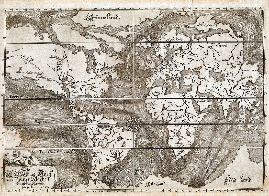
| Ocean currents global map. 17th-century map showing ocean currents (dark lines) based on the observations of explorers and mariners. Features include whirlpools and four markings (possibly subterranean tunnels) linking seas and oceans (Black Sea-Caspian Sea; Caspian Sea-Persian Gulf; Mediterranean Sea-Red Sea; and Atlantic-Pacific at Panama). Volcanoes and mountains and rivers are shown in various locations. Areas with poorly understood geography include Australia,California and eastern Asia. This map (German title at lower left: 'Die Ebbe und Fluth auff einer flachen Landt-Karten furgestelt') was published by Eberhard Werner Happel in Ulm in 1687 | |
| Lizenzart: | Lizenzpflichtig |
| Credit: | Science Photo Library / British Library |
| Bildgröße: | 5417 px × 3952 px |
| Modell-Rechte: | nicht erforderlich |
| Eigentums-Rechte: | nicht erforderlich |
| Restrictions: | - |
Preise für dieses Bild ab 15 €
Universitäten & Organisationen
(Informationsmaterial Digital, Informationsmaterial Print, Lehrmaterial Digital etc.)
ab 15 €
Redaktionell
(Bücher, Bücher: Sach- und Fachliteratur, Digitale Medien (redaktionell) etc.)
ab 30 €
Werbung
(Anzeigen, Aussenwerbung, Digitale Medien, Fernsehwerbung, Karten, Werbemittel, Zeitschriften etc.)
ab 55 €
Handelsprodukte
(bedruckte Textilie, Kalender, Postkarte, Grußkarte, Verpackung etc.)
ab 75 €
Pauschalpreise
Rechtepakete für die unbeschränkte Bildnutzung in Print oder Online
ab 495 €
Keywords
- 1600er Jahre,
- 17. Jahrhundert,
- Afrika,
- Afrikanisch,
- Amerika,
- Amerikanisch,
- Antarktis,
- Äquator,
- Arktis,
- Asiatisch,
- Asien,
- Atlantisch,
- Berge,
- Deutsche,
- Diagramm,
- Einfarbig,
- Europa,
- europäisch,
- Flüsse,
- geografisch,
- Geographie,
- Geschichte,
- historisch,
- Illustration,
- Indisch,
- Kalifornien,
- Kartographie,
- Kaspisches Meer,
- Kontinent,
- Kunstwerk,
- Land,
- Marine,
- Meer,
- Meereskunde,
- Mittelmeer,
- Niemand,
- Nordamerika,
- Ozean,
- Ozeane,
- Panama,
- Pazifik,
- Persischer Golf,
- planetarisch,
- Rotes Meer,
- Schwarz und weiß,
- schwarzes Meer,
- Südamerika,
- Ulm,
- Untergrund,
- Vulkan,
- Vulkane,
- vulkanisch,
- Weltkarte,
- weltweit