Commissioners' Plan of Manhattan,1811
Bildnummer 11727716
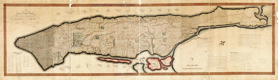
| Commissioners' Plan of 1811 for the island of Manhattan,laying out the famous grid pattern for the main streets of New York,USA. Commissioned in 1807,this map was published in 1811. North is towards upper right. The map shows ward boundaries and early parks. Central Park was not part of the original plan,but 'The Parade' (centre left) became Madison Square Park. The Hudson River (top) and East River (bottom) are labelled,as are Blackwell's Island (now Roosevelt Island) and Great Barn Island and Randell's Island (now Randalls and Wards Islands). The text at lower right consists of attestations by those publishing the map | |
| Lizenzart: | Lizenzpflichtig |
| Credit: | Science Photo Library / LIBRARY OF CONGRESS, Geography and Map Division |
| Bildgröße: | 9840 px × 2851 px |
| Modell-Rechte: | nicht erforderlich |
| Eigentums-Rechte: | nicht erforderlich |
| Restrictions: | - |
Preise für dieses Bild ab 15 €
Universitäten & Organisationen
(Informationsmaterial Digital, Informationsmaterial Print, Lehrmaterial Digital etc.)
ab 15 €
Redaktionell
(Bücher, Bücher: Sach- und Fachliteratur, Digitale Medien (redaktionell) etc.)
ab 30 €
Werbung
(Anzeigen, Aussenwerbung, Digitale Medien, Fernsehwerbung, Karten, Werbemittel, Zeitschriften etc.)
ab 55 €
Handelsprodukte
(bedruckte Textilie, Kalender, Postkarte, Grußkarte, Verpackung etc.)
ab 75 €
Pauschalpreise
Rechtepakete für die unbeschränkte Bildnutzung in Print oder Online
ab 495 €
Keywords
- 1800er Jahre,
- 19. Jahrhundert,
- Alleen,
- Amerikanisch,
- beschriftet,
- East River,
- Englisch,
- Etikette,
- Etiketten,
- geografisch,
- Geographie,
- Geschichte,
- historisch,
- Illustration,
- Insel,
- Inseln,
- Karte,
- Kartographie,
- Kunstwerk,
- Manhattan,
- menschliche Geografie,
- New York,
- New York City,
- Niemand,
- Nordamerika,
- nordamerikanisch,
- NYC,
- Park,
- Parks,
- Planen,
- Stadt,
- städtisch,
- Text,
- uns,
- USA,
- Vereinigte Staaten