Greenland Ice Sheet stratigraphy
Bildnummer 11718661
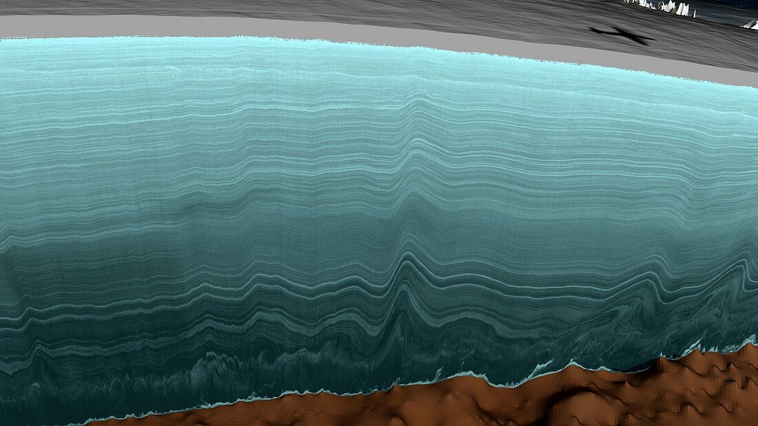
| Greenland Ice Sheet stratigraphy. Computer graphic showing the stratigraphy data collected by a radar aircraft flight over the Greenland Ice Sheet. This is a mass of ice with an area of 1.7 million square kilometres,reaching a thickness of over 3 kilometres. The resulting visualisation is known as a radargram. The shadow of the aircraft is at top right. This data was collected by one of the flights that form part of NASA's Operation IceBridge (2009-2016). This flight took place on 2 May 2011. The oldest ice,across bottom near the bedrock,is over 90,000 years old. For the lines colour-coded and with age labels,see image C025/8969 | |
| Lizenzart: | Lizenzpflichtig |
| Credit: | Science Photo Library / Scientific Visualization Studio / NASA |
| Bildgröße: | 5573 px × 3135 px |
| Modell-Rechte: | nicht erforderlich |
| Eigentums-Rechte: | nicht erforderlich |
| Restrictions: | - |
Preise für dieses Bild ab 15 €
Universitäten & Organisationen
(Informationsmaterial Digital, Informationsmaterial Print, Lehrmaterial Digital etc.)
ab 15 €
Redaktionell
(Bücher, Bücher: Sach- und Fachliteratur, Digitale Medien (redaktionell) etc.)
ab 30 €
Werbung
(Anzeigen, Aussenwerbung, Digitale Medien, Fernsehwerbung, Karten, Werbemittel, Zeitschriften etc.)
ab 55 €
Handelsprodukte
(bedruckte Textilie, Kalender, Postkarte, Grußkarte, Verpackung etc.)
ab 75 €
Pauschalpreise
Rechtepakete für die unbeschränkte Bildnutzung in Print oder Online
ab 495 €