Lake Urmia,Iran,1998,satellite image
Bildnummer 11698118
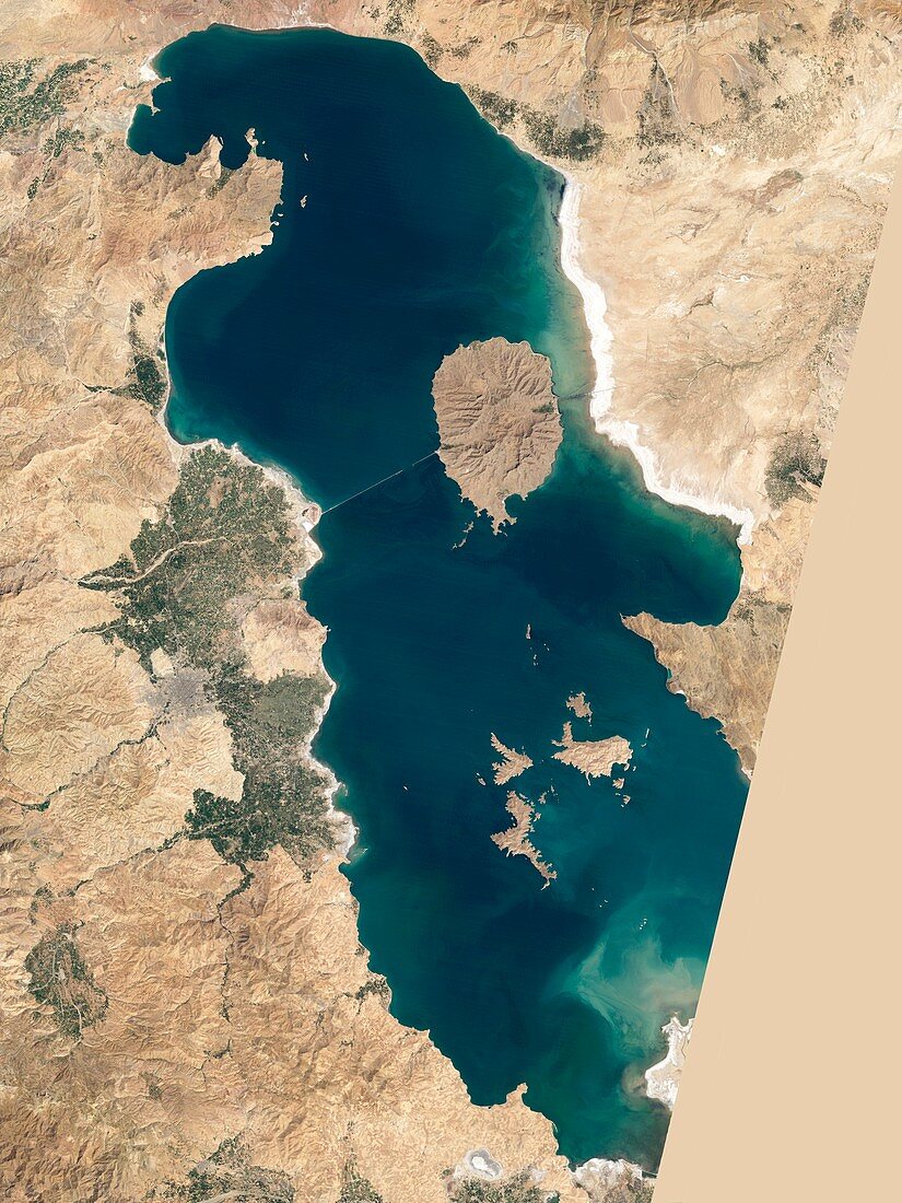
| Lake Urmia,1998. Satellite image showing the water level of Lake Urmia (or Orumiyeh),Iran,in 1998. Lake Urmia is one of the world's largest landlocked salt lakes,but it is shrinking. Here,there is an island at upper centre,however in a similar image taken in 2011 it is a rocky outcrop surrounded by dry land. The cause of Orumiyeh's depletion is disputed. The Iranian government blames climate change and drought,while many citizens blame damming of rivers by the government. Imaged by the Thematic Mapper on NASA's Landsat 5 satellite,on 25 August 1998 | |
| Lizenzart: | Lizenzpflichtig |
| Credit: | Science Photo Library / NASA Earth Observatory |
| Bildgröße: | 3627 px × 4835 px |
| Modell-Rechte: | nicht erforderlich |
| Eigentums-Rechte: | nicht erforderlich |
| Restrictions: | - |
Preise für dieses Bild ab 15 €
Universitäten & Organisationen
(Informationsmaterial Digital, Informationsmaterial Print, Lehrmaterial Digital etc.)
ab 15 €
Redaktionell
(Bücher, Bücher: Sach- und Fachliteratur, Digitale Medien (redaktionell) etc.)
ab 30 €
Werbung
(Anzeigen, Aussenwerbung, Digitale Medien, Fernsehwerbung, Karten, Werbemittel, Zeitschriften etc.)
ab 55 €
Handelsprodukte
(bedruckte Textilie, Kalender, Postkarte, Grußkarte, Verpackung etc.)
ab 75 €
Pauschalpreise
Rechtepakete für die unbeschränkte Bildnutzung in Print oder Online
ab 495 €
Keywords
- 20. Jahrhundert,
- Asiatisch,
- Asien,
- Dürre,
- Erdbeobachtung,
- geografisch,
- Geographie,
- groß,
- Hydrologie,
- Insel,
- Iran,
- iranisch,
- Klimatologie,
- klimatologisch,
- Klimawandel,
- kontrovers,
- Meteorologie,
- meteorologisch,
- Mittlerer Osten,
- Nahost,
- Niemand,
- Persien,
- Salzsee,
- Satellit,
- Satellitenbild,
- Umwelt,
- Umweltwissenschaften,
- Von Oben,
- Wasser,
- Weltall