Basin of the North Atlantic Ocean,1854
Bildnummer 11653799
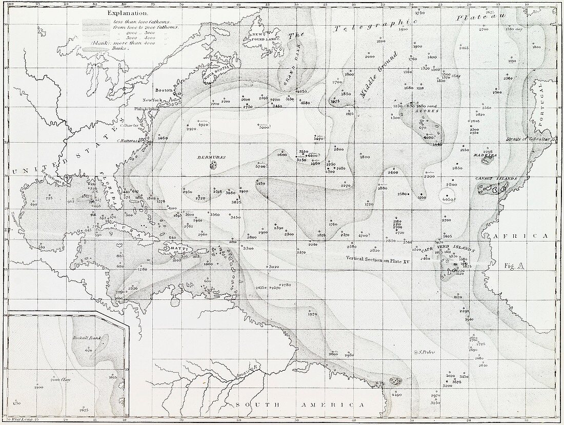
| Basin of the North Atlantic Ocean. 1854 edition of the first printed bathymetric map,showing seabed depths in the North Atlantic. The original data was gathered in the 1830s. The maps were produced by US naval officer and oceanographer Matthew Fontaine Maury (1806-1873),first superintendent of the United States Naval Observatory. Depths are shown to 4000 fathoms (7.3 kilometres). An inset (lower left) shows the Rockall Bank off Ireland. 'The Telegraphic Plateau' (top) was later identified as part of the mid-ocean ridge. Map published in Maury's 'Explanations and Sailing Directions to Accompany the Wind and Current Charts' (1854) | |
| Lizenzart: | Lizenzpflichtig |
| Credit: | Science Photo Library / NEW YORK PUBLIC LIBRARY / GENERAL RESEARCH DIVISION |
| Bildgröße: | 3737 px × 2817 px |
| Modell-Rechte: | nicht erforderlich |
| Eigentums-Rechte: | nicht erforderlich |
| Restrictions: | - |
Preise für dieses Bild ab 15 €
Universitäten & Organisationen
(Informationsmaterial Digital, Informationsmaterial Print, Lehrmaterial Digital etc.)
ab 15 €
Redaktionell
(Bücher, Bücher: Sach- und Fachliteratur, Digitale Medien (redaktionell) etc.)
ab 30 €
Werbung
(Anzeigen, Aussenwerbung, Digitale Medien, Fernsehwerbung, Karten, Werbemittel, Zeitschriften etc.)
ab 55 €
Handelsprodukte
(bedruckte Textilie, Kalender, Postkarte, Grußkarte, Verpackung etc.)
ab 75 €
Pauschalpreise
Rechtepakete für die unbeschränkte Bildnutzung in Print oder Online
ab 495 €
Keywords
- 1800er Jahre,
- 19. Jahrhundert,
- Atlantisch,
- Azoren,
- Bathymetrie,
- bathymetrisch,
- Becken,
- Diagramm,
- Einfarbig,
- erst,
- Europa,
- europäisch,
- Florida,
- früh,
- geografisch,
- Geographie,
- Geschichte,
- historisch,
- Illustration,
- Kanarische Inseln,
- Karibik,
- Karte,
- Kartographie,
- Kuba,
- Madeira,
- Meer,
- Meeresboden,
- Meereskunde,
- Neufundland,
- Nordamerika,
- nordamerikanisch,
- Ozean,
- Plateau,
- Schwarz und weiß,
- Topographie,
- Trog,
- USNO,
- wegweisend