North-western Atlantic,oceanography data
Bildnummer 11648953
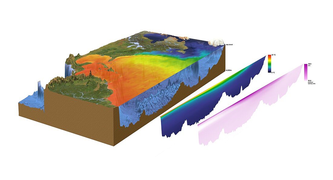
| North-western Atlantic,oceanography data. Cutaway block diagram of the north-western Atlantic Ocean,showing in exaggerated form the height of land terrain and the depth of the seabed,plus sea surface temperature (SST) and salinity data. The depth ranges from sea level to 6000 metres (labelled at upper right). At right are a colour-coded temperature depth profile (ranging from 0 to 32 degrees Celsius,same colours apply to the SST data) and a shading-coded salinity depth profile (pink,35 to 38 parts per thousand). The areas shown include parts of North America,the northern part of South America,the southern tip of Greenland,and the islands of the Caribbean | |
| Lizenzart: | Lizenzpflichtig |
| Credit: | Science Photo Library / Planetary Visions |
| Bildgröße: | 4999 px × 2703 px |
| Modell-Rechte: | nicht erforderlich |
| Eigentums-Rechte: | nicht erforderlich |
| Restrictions: | - |
Preise für dieses Bild ab 15 €
Universitäten & Organisationen
(Informationsmaterial Digital, Informationsmaterial Print, Lehrmaterial Digital etc.)
ab 15 €
Redaktionell
(Bücher, Bücher: Sach- und Fachliteratur, Digitale Medien (redaktionell) etc.)
ab 30 €
Werbung
(Anzeigen, Aussenwerbung, Digitale Medien, Fernsehwerbung, Karten, Werbemittel, Zeitschriften etc.)
ab 55 €
Handelsprodukte
(bedruckte Textilie, Kalender, Postkarte, Grußkarte, Verpackung etc.)
ab 75 €
Pauschalpreise
Rechtepakete für die unbeschränkte Bildnutzung in Print oder Online
ab 495 €
Keywords
- 1,
- Anden,
- Atlantischer Ozean,
- ausgeschnitten,
- Ausschnitte,
- Bathymetrie,
- bathymetrisch,
- Berge,
- Cutaway,
- Eis,
- Erdkunde,
- farbcodiert,
- Florida,
- Fluss,
- geografisch,
- Geographie,
- Geologie,
- geologisch,
- Illustration,
- Insel,
- Inseln,
- Karibik,
- Kontinent,
- Kuba,
- Kunstwerk,
- Küste,
- Küsten-,
- Land,
- Lateinamerika,
- Meer,
- Meeresboden,
- Meereskunde,
- Modell-,
- Nordamerika,
- nordamerikanisch,
- Ozean,
- Regale,
- Salzig,
- Salzwasser,
- Satellitenbilder,
- schattiert,
- sst,
- Südamerika,
- Südamerikanisch,
- Tief,
- Tiefe,
- topografisch,
- Topographie,
- unter Wasser,
- Unterwasser,
- Variation,
- weißer Hintergrund