North-western Atlantic,bathymetry model
Bildnummer 11648952
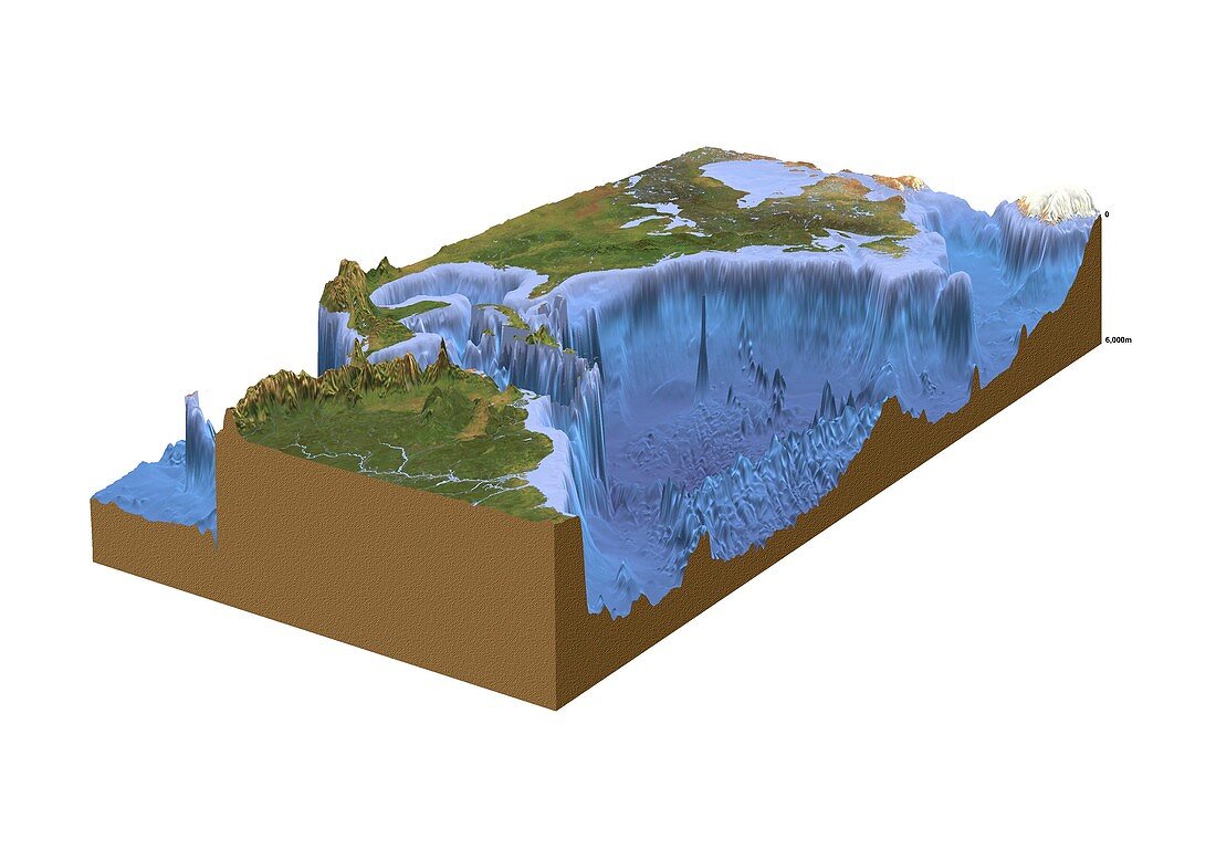
| North-western Atlantic,bathymetry model. Cutaway block diagram of the north-western Atlantic Ocean,showing in exaggerated form the height of land terrain and the depth of the seabed. Satellite images are used for the land. The seabed is based on a digital bathymetric map,with depth ranging from 0 to 6000 metres (labelled at upper right). Shown here are parts of North America (including Hudson Bay,the Great Lakes,and Florida),northern part of South America (including the northern Andes and the Amazon),southern tip of Greenland,and the islands of the Caribbean (including Cuba and Hispaniola). The island seamount just right of centre is Bermuda | |
| Lizenzart: | Lizenzpflichtig |
| Credit: | Science Photo Library / Planetary Visions |
| Bildgröße: | 3738 px × 2613 px |
| Modell-Rechte: | nicht erforderlich |
| Eigentums-Rechte: | nicht erforderlich |
| Restrictions: | - |
Preise für dieses Bild ab 15 €
Universitäten & Organisationen
(Informationsmaterial Digital, Informationsmaterial Print, Lehrmaterial Digital etc.)
ab 15 €
Redaktionell
(Bücher, Bücher: Sach- und Fachliteratur, Digitale Medien (redaktionell) etc.)
ab 30 €
Werbung
(Anzeigen, Aussenwerbung, Digitale Medien, Fernsehwerbung, Karten, Werbemittel, Zeitschriften etc.)
ab 55 €
Handelsprodukte
(bedruckte Textilie, Kalender, Postkarte, Grußkarte, Verpackung etc.)
ab 75 €
Pauschalpreise
Rechtepakete für die unbeschränkte Bildnutzung in Print oder Online
ab 495 €
Keywords
- 1,
- Anden,
- Atlantischer Ozean,
- ausgeschnitten,
- Ausschnitte,
- Bathymetrie,
- bathymetrisch,
- Berge,
- Cutaway,
- Eis,
- Erdkunde,
- Florida,
- Fluss,
- geografisch,
- Geographie,
- Geologie,
- geologisch,
- Illustration,
- Insel,
- Inseln,
- Karibik,
- Kontinent,
- Kuba,
- Kunstwerk,
- Küste,
- Küsten-,
- Land,
- Lateinamerika,
- Meer,
- Meeresboden,
- Meereskunde,
- Modell-,
- Nordamerika,
- nordamerikanisch,
- Ozean,
- Regale,
- Satellitenbilder,
- Südamerika,
- Südamerikanisch,
- Tief,
- Tiefe,
- topografisch,
- Topographie,
- unter Wasser,
- Unterwasser,
- weißer Hintergrund