Ile-de-France,France,satellite image
Bildnummer 11639714
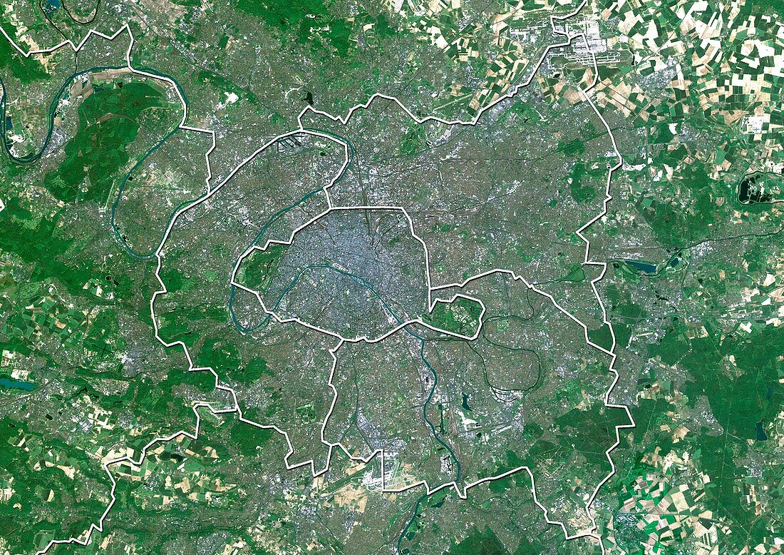
| Ile-de-France,France. North is at top. Natural colour satellite image of a close-up on the Ile-de-France administrative region of France,showing Paris (centre) and the departments of Seine-Saint-Denis (upper right),Seine-et-Marne (right),Val-de-Marne,(lower right),Hauts-de-Seine (lower left),Val-d'Oise (top centre),Essonne (bottom centre),and Yvelines (left). France is located in Western Europe. Paris is the capital and largest city of France. Bot it and Seine-Saint-Denis are located in northern France,at the heart of the Ile-de-France region. Image compiled from data acquired by the LANDSAT 5 and 7 satellites,in 2000. Images highlighting all other regions of this country are available. For further information please contact SPL | |
| Lizenzart: | Lizenzpflichtig |
| Credit: | Science Photo Library / Planetobserver |
| Bildgröße: | 4978 px × 3520 px |
| Modell-Rechte: | nicht erforderlich |
| Restrictions: | - |
Preise für dieses Bild ab 15 €
Universitäten & Organisationen
(Informationsmaterial Digital, Informationsmaterial Print, Lehrmaterial Digital etc.)
ab 15 €
Redaktionell
(Bücher, Bücher: Sach- und Fachliteratur, Digitale Medien (redaktionell) etc.)
ab 30 €
Werbung
(Anzeigen, Aussenwerbung, Digitale Medien, Fernsehwerbung, Karten, Werbemittel, Zeitschriften etc.)
ab 55 €
Handelsprodukte
(bedruckte Textilie, Kalender, Postkarte, Grußkarte, Verpackung etc.)
ab 75 €
Pauschalpreise
Rechtepakete für die unbeschränkte Bildnutzung in Print oder Online
ab 495 €
Keywords
- 2000,
- 21. Jahrhundert,
- Abteilung,
- Abteilungen,
- Erdbeobachtung,
- Essonne,
- Europa,
- europäisch,
- Frankreich,
- Französisch,
- geografisch,
- Geographie,
- Grenze,
- Grenzen,
- hauts-de-Seine,
- Karte,
- Kartographie,
- Land,
- Länder,
- Landsat 7,
- Nation,
- Natur,
- Natürliche Farbe,
- Norden,
- Paris,
- Rand,
- Region,
- Satellit,
- Satellitenbild,
- Seine-et-Marne,
- Seine-Saint-Denis,
- topografisch,
- Topographie,
- Umwelt,
- Val-de-Marne,
- Verwaltungsregion,
- Vogelperspektive,
- Von Oben,
- Weltall,
- Westeuropa