Caribbean topography,ETOPO1 model
Bildnummer 11622029
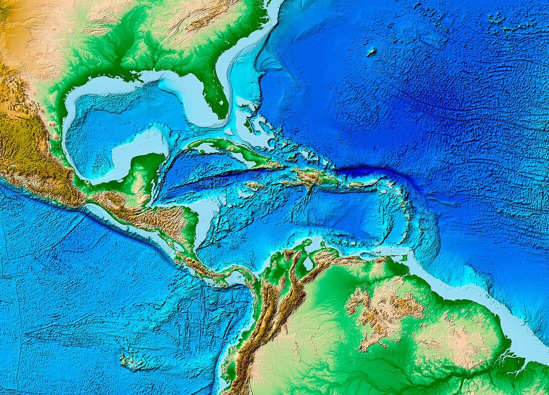
| Caribbean topography,ETOPO1 model. Colours on land indicate vegetation (green),dry areas (brown),high mountains (dark brown),and snow and ice (white). On the ocean floors,prominent features include deep waters (dark blue) and continental shelves (light blue). Global,regional and coastal datasets (including GLOBE,Measured and Estimated Seafloor Bathymetry,and SRTM) were used. ETOPO1 (2009) was produced by the National Geophysical Data Center of the National Oceanic and Atmospheric Administration (NOAA) | |
| Lizenzart: | Lizenzpflichtig |
| Credit: | Science Photo Library / NOAA |
| Bildgröße: | 4942 px × 3555 px |
| Modell-Rechte: | nicht erforderlich |
| Eigentums-Rechte: | nicht erforderlich |
| Restrictions: |
|
Preise für dieses Bild ab 15 €
Universitäten & Organisationen
(Informationsmaterial Digital, Informationsmaterial Print, Lehrmaterial Digital etc.)
ab 15 €
Redaktionell
(Bücher, Bücher: Sach- und Fachliteratur, Digitale Medien (redaktionell) etc.)
ab 30 €
Werbung
(Anzeigen, Aussenwerbung, Digitale Medien, Fernsehwerbung, Karten, Werbemittel, Zeitschriften etc.)
ab 55 €
Handelsprodukte
(bedruckte Textilie, Kalender, Postkarte, Grußkarte, Verpackung etc.)
ab 75 €
Pauschalpreise
Rechtepakete für die unbeschränkte Bildnutzung in Print oder Online
ab 495 €
Keywords
- 21. Jahrhundert,
- abgebildet,
- Bathymetrie,
- bathymetrisch,
- Erde,
- Erdkunde,
- Erdtopographie,
- ETOPO-1,
- geografisch,
- Geographie,
- Geologie,
- geologisch,
- Globus,
- Golf von Mexiko,
- Karibik,
- Karte,
- Land,
- Meer,
- Meeresboden,
- Meereskunde,
- Modell-,
- NGDC,
- NOAA,
- Ozean,
- Ozeane,
- Projektion,
- SRTM,
- topografisch,
- Topographie,
- unter Wasser,
- Unterwasser,
- Wasser,
- Zentralamerika