Earth's topography and bathymetry
Bildnummer 11618130
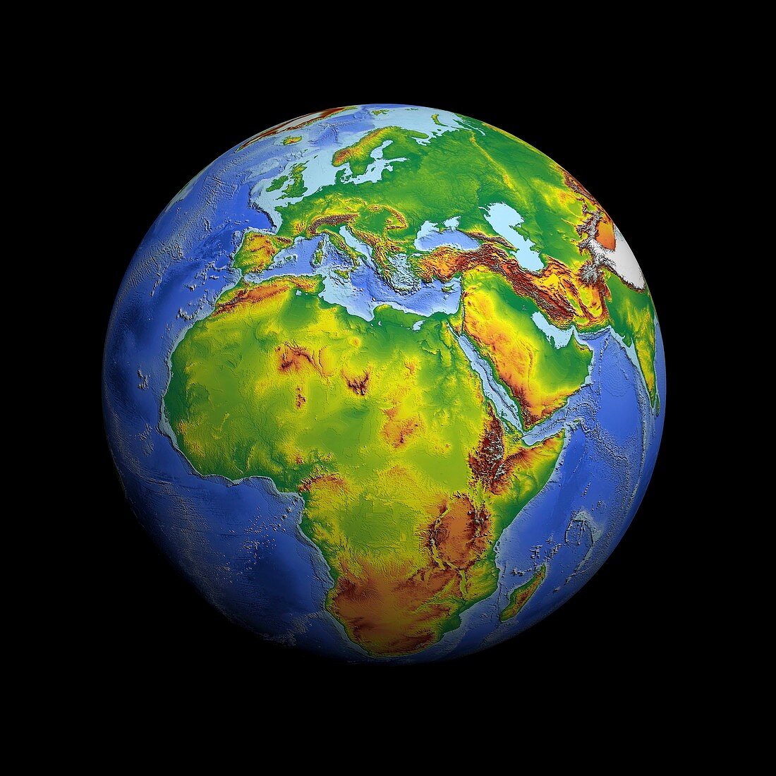
| Earth's topography and bathymetry. Satellite radar altimeter image showing Earth's land elevation and ocean bathymetry (depths). This image uses the most complete grid of sea-floor topography currently available,which was constructed by combining depth soundings collected from ships,with detailed gravity anomaly information obtained from the Geosat (US Navy) and ERS-1/2 (ESA) satellite altimetry missions. The final image was created by merging the bathymetry model,built by Dr. Walter Smith from NOAA (National Oceanic and Atmospheric Administration) Geosciences Lab and Professor David Sandwell from Scripps Institution of Oceanography,USA,with the Altimetry Corrected Elevations (ACE) produced by Professor Philippa Berry of the De Montfort University | |
| Lizenzart: | Lizenzpflichtig |
| Credit: | Science Photo Library / ESA / NOAA / DMU |
| Bildgröße: | 3496 px × 3496 px |
| Modell-Rechte: | nicht erforderlich |
| Restrictions: |
|
Preise für dieses Bild ab 15 €
Universitäten & Organisationen
(Informationsmaterial Digital, Informationsmaterial Print, Lehrmaterial Digital etc.)
ab 15 €
Redaktionell
(Bücher, Bücher: Sach- und Fachliteratur, Digitale Medien (redaktionell) etc.)
ab 30 €
Werbung
(Anzeigen, Aussenwerbung, Digitale Medien, Fernsehwerbung, Karten, Werbemittel, Zeitschriften etc.)
ab 55 €
Handelsprodukte
(bedruckte Textilie, Kalender, Postkarte, Grußkarte, Verpackung etc.)
ab 75 €
Pauschalpreise
Rechtepakete für die unbeschränkte Bildnutzung in Print oder Online
ab 495 €
Keywords
- Afrika,
- Altimetrie,
- altimetrisch,
- Astronomie,
- astronomisch,
- Bathymetrie,
- bathymetrisch,
- Erdbeobachtung,
- Erde,
- esa,
- Europäische Weltraumbehörde,
- farbcodiert,
- geografisch,
- Geographie,
- Globus,
- Höhe,
- kombiniert,
- Kontinent,
- Kontinente,
- Labor,
- Meer,
- Meeresboden,
- Ozean,
- Ozeane,
- Planetenwissenschaft,
- Raum,
- Satellitenbild,
- schwarzer Hintergrund,
- Sonnensystem,
- Tiefe,
- topografisch,
- Topographie,
- Wasser,
- weltweit,
- Zusammengesetzt