Greenwich and Paris Meridians,1799
Bildnummer 11602158
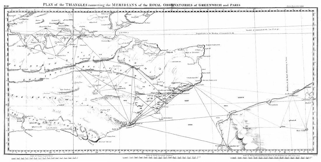
| Greenwich and Paris Meridians. Map showing the triangulation triangles connecting the Greenwich and Paris Meridians,allowing maps constructed under the rival systems to be compared. Large theodolites were used to take measurements across the Channel. The French continued to use the Paris Meridian for several decades after the Greenwich Meridian was adopted internationally in 1884. This work was first published in Philosophical Transactions of the Royal Society,then in volume one of a 1799 report by Mudge and Dalby for the UK's Board of Ordnance. This would later form the basis of the UK national mapping agency,the Ordnance Survey | |
| Lizenzart: | Lizenzpflichtig |
| Credit: | Science Photo Library / Royal Astronomical Society |
| Bildgröße: | 5942 px × 3000 px |
| Modell-Rechte: | nicht erforderlich |
| Eigentums-Rechte: | nicht erforderlich |
| Restrictions: | - |
Preise für dieses Bild ab 15 €
Universitäten & Organisationen
(Informationsmaterial Digital, Informationsmaterial Print, Lehrmaterial Digital etc.)
ab 15 €
Redaktionell
(Bücher, Bücher: Sach- und Fachliteratur, Digitale Medien (redaktionell) etc.)
ab 30 €
Werbung
(Anzeigen, Aussenwerbung, Digitale Medien, Fernsehwerbung, Karten, Werbemittel, Zeitschriften etc.)
ab 55 €
Handelsprodukte
(bedruckte Textilie, Kalender, Postkarte, Grußkarte, Verpackung etc.)
ab 75 €
Pauschalpreise
Rechtepakete für die unbeschränkte Bildnutzung in Print oder Online
ab 495 €
Keywords
- 1700er Jahre,
- 18. Jahrhundert,
- Anschluss-,
- britisch,
- Diagramm,
- Dreiecke,
- Einfarbig,
- England,
- Englisch,
- erst,
- Europa,
- europäisch,
- Frankreich,
- Französisch,
- früh,
- geografisch,
- Geographie,
- Geschichte,
- Großbritannien,
- historisch,
- Illustration,
- Inseln,
- International,
- Karte,
- Karten,
- Kartographie,
- Königliche Gesellschaft,
- Kunstwerk,
- Küste,
- Küsten-,
- Messung,
- Militär-,
- nationale Agentur,
- Organisation,
- Philosophische Transaktionen,
- Schwarz und weiß,
- Surfen,
- Surfer,
- Trigonometrie,
- Trigonometrische Vermessung,
- unter Wasser,
- unterhalb,
- Vereinigtes Königreich,
- von unten,
- Wasser,
- wegweisend,
- Welle,
- Wellen,
- wissenschaftlich