Global land and sea floor topography
Bildnummer 11600112
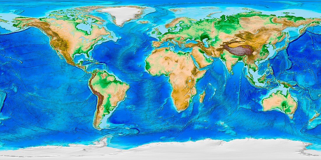
| Global land and sea floor topography. Computer map of the topography of the world and its coastal and inland regions. The map includes colour-coding of land cover,including vegetation (green),dry areas (brown),high mountains (dark brown),and snow and ice (white). On the ocean floors,prominent features include the spreading mid-ocean ridges in the Atlantic,Pacific and Indian oceans. Subduction trenches are dark blue,and continental shelves are light blue. This map,using the ETOPO-1 dataset,was produced by the National Geophysical Data Center of the National Oceanic and Atmospheric Administration (NOAA).<br>Restrictions: | |
| Lizenzart: | Lizenzpflichtig |
| Credit: | Science Photo Library / NOAA |
| Bildgröße: | 8500 px × 4250 px |
| Modell-Rechte: | nicht erforderlich |
| Eigentums-Rechte: | nicht erforderlich |
| Restrictions: |
|
Preise für dieses Bild ab 15 €
Universitäten & Organisationen
(Informationsmaterial Digital, Informationsmaterial Print, Lehrmaterial Digital etc.)
ab 15 €
Redaktionell
(Bücher, Bücher: Sach- und Fachliteratur, Digitale Medien (redaktionell) etc.)
ab 30 €
Werbung
(Anzeigen, Aussenwerbung, Digitale Medien, Fernsehwerbung, Karten, Werbemittel, Zeitschriften etc.)
ab 55 €
Handelsprodukte
(bedruckte Textilie, Kalender, Postkarte, Grußkarte, Verpackung etc.)
ab 75 €
Pauschalpreise
Rechtepakete für die unbeschränkte Bildnutzung in Print oder Online
ab 495 €
Keywords
- 21. Jahrhundert,
- abgebildet,
- Afrika,
- Afrikanisch,
- Asiatisch,
- Asien,
- Bathymetrie,
- bathymetrisch,
- Erde,
- Erdkunde,
- ETOPO-1,
- Europa,
- europäisch,
- geografisch,
- Geographie,
- Geologie,
- geologisch,
- Karte,
- Kontinent,
- Kontinente,
- Land,
- Meer,
- Meeresboden,
- Modell-,
- NGDC,
- NOAA,
- Nordamerika,
- nordamerikanisch,
- Ozean,
- Ozeane,
- Planet,
- Projektion,
- Südamerika,
- Südamerikanisch,
- topografisch,
- Topographie,
- Unterwasser,
- Welt,
- weltweit