North-West Pacific topography
Bildnummer 11600111
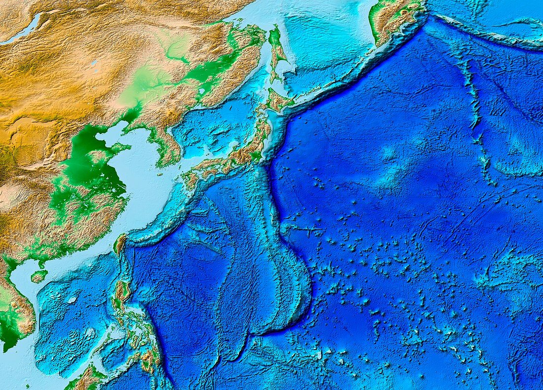
| North-West Pacific topography. Computer map of the topography of the North-West Pacific Ocean,its coastal regions,and parts of East Asia. The main feature is the dark line running through centre. This is a series of tectonic plate boundaries,marked by deep subduction trenches. It was here,near Japan (upper centre),that a massive offshore earthquake on 11 March 2011 caused a powerful tsunami. This tsunami devastated the coast and cities of north-eastern Japan. This map,using the ETOPO-1 dataset,was produced by the National Geophysical Data Center of the National Oceanic and Atmospheric Administration (NOAA).<br>Restrictions: | |
| Lizenzart: | Lizenzpflichtig |
| Credit: | Science Photo Library / NOAA |
| Bildgröße: | 4961 px × 3566 px |
| Modell-Rechte: | nicht erforderlich |
| Eigentums-Rechte: | nicht erforderlich |
| Restrictions: |
|
Preise für dieses Bild ab 15 €
Universitäten & Organisationen
(Informationsmaterial Digital, Informationsmaterial Print, Lehrmaterial Digital etc.)
ab 15 €
Redaktionell
(Bücher, Bücher: Sach- und Fachliteratur, Digitale Medien (redaktionell) etc.)
ab 30 €
Werbung
(Anzeigen, Aussenwerbung, Digitale Medien, Fernsehwerbung, Karten, Werbemittel, Zeitschriften etc.)
ab 55 €
Handelsprodukte
(bedruckte Textilie, Kalender, Postkarte, Grußkarte, Verpackung etc.)
ab 75 €
Pauschalpreise
Rechtepakete für die unbeschränkte Bildnutzung in Print oder Online
ab 495 €
Keywords
- 21. Jahrhundert,
- abgebildet,
- Asiatisch,
- Asien,
- Bathymetrie,
- bathymetrisch,
- Erdkunde,
- ETOPO-1,
- geografisch,
- Geographie,
- Geologie,
- geologisch,
- Grenzen,
- Insel,
- Japan,
- Japanisch,
- Karte,
- Linien,
- Marianengraben,
- Meeresboden,
- Modell-,
- NGDC,
- NOAA,
- Ozean,
- Pazifik,
- Plattentektonik,
- Seismologie,
- Teller,
- topografisch,
- Topographie,
- Unterwasser