Effects of 2011 tsunami,Japan
Bildnummer 11600094
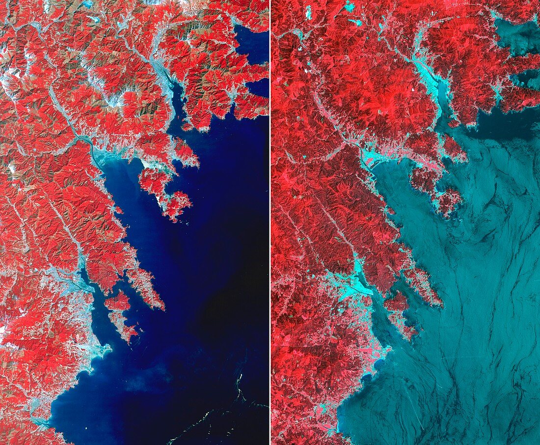
| Effects of 2011 tsunami. ASTER infrared satellite images showing an area of coastline in north-eastern Japan after (left) and before (right) the devastating earthquake and tsunami of 11 March 2011. North is at top. Vegetation is red and urban areas are light blue. The three cities (top to bottom) are: Ofunato,Rikuzentakata,and Kesennuma. The visible change is loss of coastal vegetation and flooding of the cities. The images cover an area 28 by 46 kilometres,and were obtained on 14 March 2011 and in August 2008 with the Advanced Spaceborne Thermal Emission and Reflection Radiometer (ASTER) instrument on NASA's Terra satellite | |
| Lizenzart: | Lizenzpflichtig |
| Credit: | Science Photo Library / US-JAPAN ASTER SCIENCE TEAM / JAROS / ERSDAC / METI / GSFC / NASA |
| Bildgröße: | 4724 px × 3892 px |
| Modell-Rechte: | nicht erforderlich |
| Eigentums-Rechte: | nicht erforderlich |
| Restrictions: | - |
Preise für dieses Bild ab 15 €
Universitäten & Organisationen
(Informationsmaterial Digital, Informationsmaterial Print, Lehrmaterial Digital etc.)
ab 15 €
Redaktionell
(Bücher, Bücher: Sach- und Fachliteratur, Digitale Medien (redaktionell) etc.)
ab 30 €
Werbung
(Anzeigen, Aussenwerbung, Digitale Medien, Fernsehwerbung, Karten, Werbemittel, Zeitschriften etc.)
ab 55 €
Handelsprodukte
(bedruckte Textilie, Kalender, Postkarte, Grußkarte, Verpackung etc.)
ab 75 €
Pauschalpreise
Rechtepakete für die unbeschränkte Bildnutzung in Print oder Online
ab 495 €
Keywords
- 2011,
- 21. Jahrhundert,
- Asiatisch,
- Asien,
- Aster,
- August,
- Berg,
- Erdkunde,
- geografisch,
- Geographie,
- Geologie,
- geologisch,
- Honshu,
- infrarot,
- ir,
- Japan,
- Japanisch,
- Katastrophe,
- Kesennuma,
- Küste,
- Land,
- März,
- Meer,
- Meereskunde,
- Naturkatastrophe,
- Ozean,
- Pazifik,
- Reihenfolge,
- Rikuzentakata,
- Satellit,
- Satellitenbild,
- Seismologie,
- Serie,
- Stadt,
- tohoku,
- Tsunami,
- überflutet,
- Veränderung,
- Vergleich,
- vergleichen,
- Verwüstung,
- Wasser,
- Weltall,
- zestört