Cuba,satellite image
Bildnummer 11563975
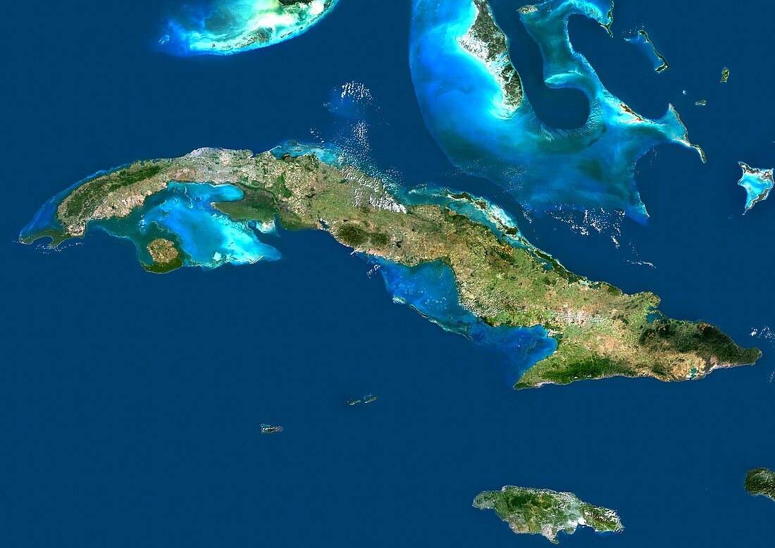
| Cuba,satellite image. North is at top. Water is blue,vegetation is brown and green,developed areas are grey/white,and clouds are white. Deep ocean is blue,with shallow areas and sand banks appearing as light blue. The island of Cuba is across centre,with the island of Jamaica at lower right,the Bahamas at upper right,the southern tip of Florida,USA,at upper left,and the Cayman Islands at lower left. Cuba is the largest island in the Caribbean. This image shows an area around 1000 kilometres across. Image data obtained by the Landsat 5 and Landsat 7 satellites | |
| Lizenzart: | Lizenzpflichtig |
| Credit: | Science Photo Library / Planetobserver |
| Bildgröße: | 4978 px × 3520 px |
| Modell-Rechte: | nicht erforderlich |
| Eigentums-Rechte: | nicht erforderlich |
| Restrictions: | - |
Preise für dieses Bild ab 15 €
Universitäten & Organisationen
(Informationsmaterial Digital, Informationsmaterial Print, Lehrmaterial Digital etc.)
ab 15 €
Redaktionell
(Bücher, Bücher: Sach- und Fachliteratur, Digitale Medien (redaktionell) etc.)
ab 30 €
Werbung
(Anzeigen, Aussenwerbung, Digitale Medien, Fernsehwerbung, Karten, Werbemittel, Zeitschriften etc.)
ab 55 €
Handelsprodukte
(bedruckte Textilie, Kalender, Postkarte, Grußkarte, Verpackung etc.)
ab 75 €
Pauschalpreise
Rechtepakete für die unbeschränkte Bildnutzung in Print oder Online
ab 495 €
Keywords
- Bahamas,
- Cayman Inseln,
- Erdbeobachtung,
- Florida,
- geografisch,
- Geographie,
- Geowissenschaften,
- Grenzen,
- Insel,
- Inseln,
- Jamaika,
- Karibik,
- Karibisches Meer,
- Kartographie,
- Kuba,
- Kubanisch,
- Küste,
- Küsten-,
- Küstenlinie,
- Land,
- Landsat 7,
- Meer,
- Nation,
- Nordamerika,
- nordamerikanisch,
- Ozean,
- Rand,
- Satellit,
- Satellitenbild,
- Topographie,
- Umwelt,
- Wasser,
- Weltall,
- Westindische Inseln