Scandinavia,satellite image
Bildnummer 11657973
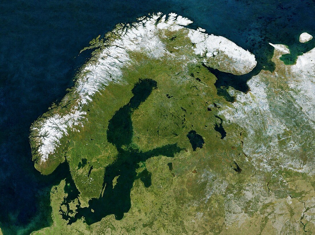
| Scandinavia,satellite image. North is at top. Snow tops the mountains of Norway (white,left) with forests and lakes covering most of Sweden (centre left) and Finland (upper centre),separated by the Baltic Sea (dark green). Estonia,Latvia and Lithuania are at lower centre. Denmark and parts of Germany and Poland are at bottom left. Parts of Russia are at right. This cloud-free,true-colour composite image was obtained in 2004. It is part of the satellite imaging project 'The Blue Marble: Next Generation'. The data was obtained by the Moderate Resolution Imaging Spectroradiometer (MODIS) sensors on NASA's Terra and Aqua satellites | |
| Lizenzart: | Lizenzpflichtig |
| Credit: | Science Photo Library / NASA |
| Bildgröße: | 5079 px × 3797 px |
| Modell-Rechte: | nicht erforderlich |
| Eigentums-Rechte: | nicht erforderlich |
| Restrictions: | - |
Preise für dieses Bild ab 15 €
Universitäten & Organisationen
(Informationsmaterial Digital, Informationsmaterial Print, Lehrmaterial Digital etc.)
ab 15 €
Redaktionell
(Bücher, Bücher: Sach- und Fachliteratur, Digitale Medien (redaktionell) etc.)
ab 30 €
Werbung
(Anzeigen, Aussenwerbung, Digitale Medien, Fernsehwerbung, Karten, Werbemittel, Zeitschriften etc.)
ab 55 €
Handelsprodukte
(bedruckte Textilie, Kalender, Postkarte, Grußkarte, Verpackung etc.)
ab 75 €
Pauschalpreise
Rechtepakete für die unbeschränkte Bildnutzung in Print oder Online
ab 495 €
Keywords
- 1,
- 21. Jahrhundert,
- aqua,
- Berge,
- Bergkette,
- Eis,
- Erdbeobachtung,
- Erdkunde,
- Estland,
- estnisch,
- Europa,
- europäisch,
- Finnisch,
- Finnland,
- geografisch,
- Geographie,
- Geowissenschaften,
- Halbinsel,
- Küste,
- Küsten,
- Küsten-,
- Küstenlinie,
- Land,
- Lettland,
- Litauen,
- Meer,
- modis,
- NASA,
- Norwegen,
- Norwegisch,
- Ostsee,
- Ozeane,
- Russisch,
- Russland,
- Satellitenbild,
- Schnee,
- Schweden,
- Schwedisch,
- Seen,
- Skandinavien,
- Skandinavisch,
- Terra,
- Vegetation,
- Wälder,
- Weltall,
- wolkenfrei,
- Zusammengesetzt