Saudi Arabia agriculture,2012
Bildnummer 11644603
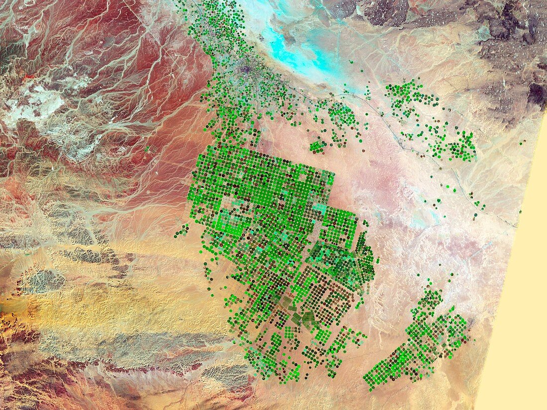
| Saudi Arabia agriculture. False-colour satellite image showing the extent of agricultural operations in the Wadi As-Sirhan Basin of Saudi Arabia in 2012. Imaged by the Thematic Mapper and Enhanced Thematic Mapper Plus on NASA's Landsat satellites. For scale,the agricultural fields in the images are about one kilometre across and use centre-pivot irrigation | |
| Lizenzart: | Lizenzpflichtig |
| Credit: | Science Photo Library / NASA |
| Bildgröße: | 4834 px × 3626 px |
| Modell-Rechte: | nicht erforderlich |
| Restrictions: | - |
Preise für dieses Bild ab 15 €
Universitäten & Organisationen
(Informationsmaterial Digital, Informationsmaterial Print, Lehrmaterial Digital etc.)
ab 15 €
Redaktionell
(Bücher, Bücher: Sach- und Fachliteratur, Digitale Medien (redaktionell) etc.)
ab 30 €
Werbung
(Anzeigen, Aussenwerbung, Digitale Medien, Fernsehwerbung, Karten, Werbemittel, Zeitschriften etc.)
ab 55 €
Handelsprodukte
(bedruckte Textilie, Kalender, Postkarte, Grußkarte, Verpackung etc.)
ab 75 €
Pauschalpreise
Rechtepakete für die unbeschränkte Bildnutzung in Print oder Online
ab 495 €
Keywords
- 2012,
- 21. Jahrhundert,
- Arabische Halbinsel,
- Asiatisch,
- Asien,
- Bauernhof,
- Bodennutzung,
- eingefärbt,
- Erdbeobachtung,
- Ernte,
- Fehlfarbe,
- Feld,
- Felder,
- Feldfrüchte,
- geografisch,
- Geographie,
- Königreich Saudi-Arabien,
- Land,
- Landwirtschaft,
- landwirtschaftlich,
- Mittlerer Osten,
- Nahost,
- Natur,
- Satellit,
- Satellitenbild,
- System,
- Umfang,
- Umwelt,
- Vogelperspektive,
- Von Oben,
- Wachstum,
- Weltall